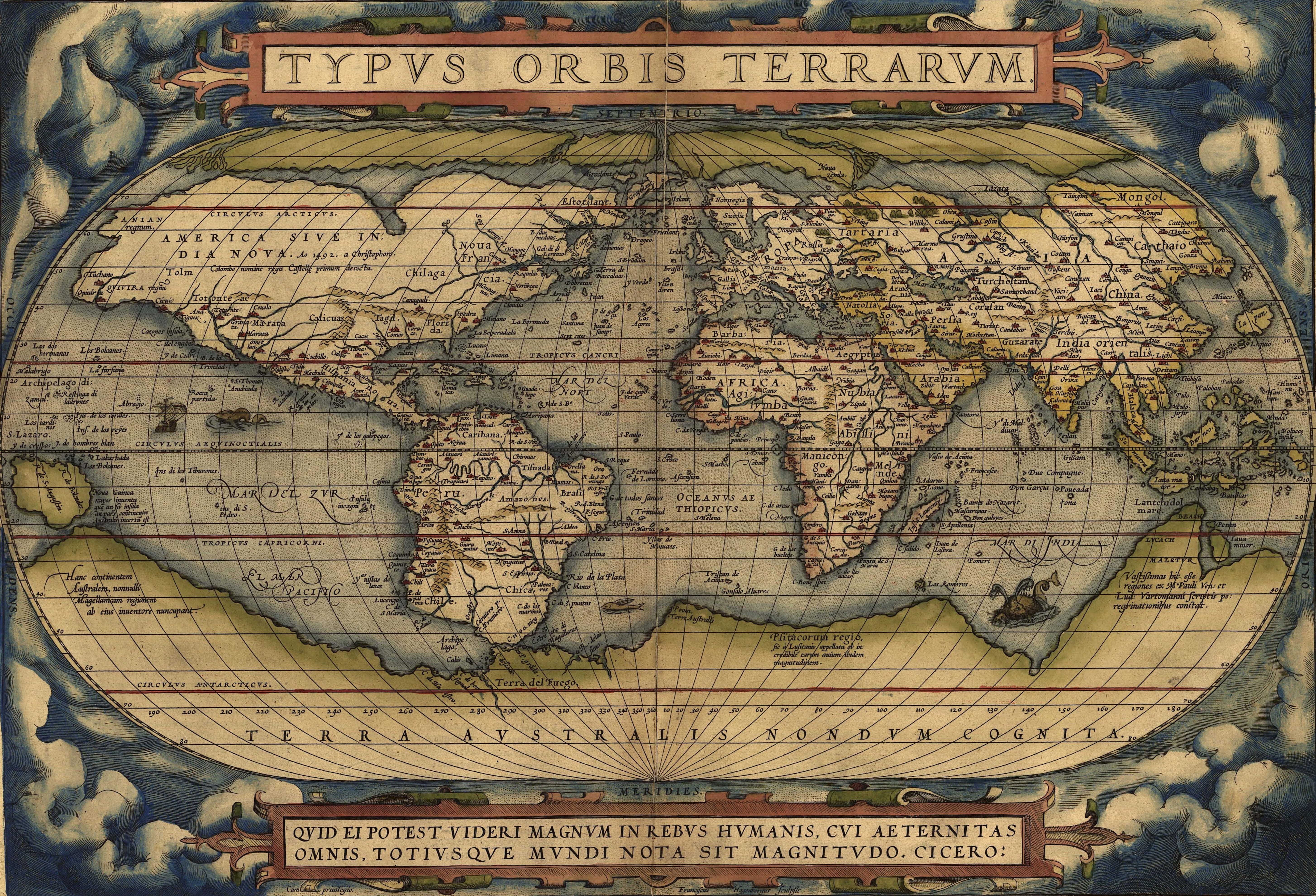
Just found this picture of a map with what looks to be Australia on it, despite the fact it wasn't sighted until decades later. Was it just a guess like the Terra Incognita southern continent?
There were theories that there has to be a large continent south from Africa to balance the weight of all the land mass on northern hemisphere.
It was usually named Terra Australis, after which Australia got its name.
In case anyone's interested, I found a similar but higher-res version of the map. The coloring is a bit different but otherwise everything else is the same. It helped me figure out that the blob on the left edge was "Noua Guinea".
Here I found a 1598 French commentary of the map which describes the southern continent depicted around the south pole as Magellana
Then we have the fifth part, located down under at the South Pole which we call Magellana, about which we cannot say very much, since we have only been informed about two or three places there, such as the Magellan straights, called Terra del Fuego [land of fire] and concerning New Guinea (which is supposed to be a part of it as well) etc.
The text on the land mass to the south of New Guinea reads "this southern continent, some call Magellana after its discoverer" and large print "terra australis nondum cognita" simply means "land of the south not yet known." Going off of the labels and the French commentary in 1598, it seems like the landmass is a guess at what lands might exist in the southern hemisphere, based on what explorers had already discovered in the Tierra del Fuego and New Guinea. In short, I don't believe this was intended to be Australia, but rather a suggestion by both mapmakers and commentators of what lay further to the south
Here's a handy guide to the map that helps with all the Latin labeling and provides bibliographic information on the map itself. Enjoy
The World Digital Library has a high-resolution scan of the entire Theater of the World if you want to see it in context. If you can read French, I believe there are sources cited (I'm on an iPhone & it's a little tedious flipping between tabs).
http://www.wdl.org/en/item/8978/view/1/14/#view=seadragon
(Disclaimer: I work on that site but as a software developer, not a content specialist)
As to the data source, http://www.samemory.sa.gov.au/site/page.cfm?u=963&c=7894 makes it sound like the overall work was a compilation of other sources and, in the case of Australia, mostly speculation.
The idea of a southern land goes back to Aristotle, who wrote 2,200 years ago:
There are two inhabitable sections of the earth: one near our upper, or nothern pole, the other near the other or southern pole; and their shape is like that of a tambourine. If you draw lines from the centre of the earth they cut out a drum-shaped figure. The lines form two cones; the base of the one is the tropic, of the other the ever visible circle, their vertex is at the centre of the earth.
He's trying to describe two inhabitable rings around the globe: one ring around the northern hemisphere and one around the southern hemisphere. These exclude the polar regions and the tropic zones, like the green zones on this diagram.
He goes on to write:
Now since there must be a region bearing the same relation to the southern pole as the place we live in bears to our pole, it will clearly correspond in the ordering of its winds as well as in other things. [... and then goes on to write about the wind patterns of the southern land compared to the northern land he and everyone else lived in]
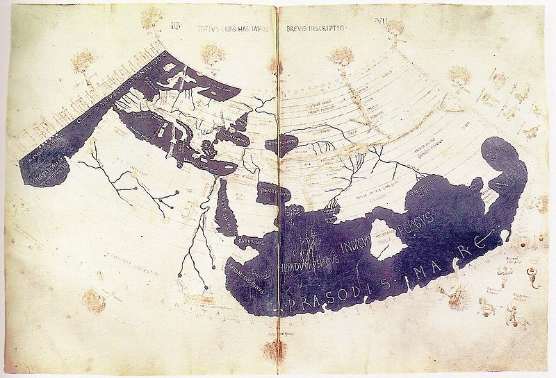
A couple of hundred years later, Ptolemy included a great southern land in his world map. The white parts are land, the blue is ocean: note the large continuous white space at the bottom of the map.
The map you’ve found, which was produced by Abraham Ortelius in 1570 using the newly devised Mercator projection, includes a few more up-to-date details like Africa, the Americas, and the islands south of Asia, including Java – and also includes Ptolemy’s and Aristotle’s southern land. Ptolemy and Aristotle were still seen as authorities, and map-makers often simply copied earlier maps in this way, even if they were based on guesses and legends.
So, yes, this southern land is what was often known in Latin as “Terra Australis Incognita” – literally, “land southern unknown”.
Here is a textual description taken from Cornelius Wyffliet’s ‘Descriptionis Ptolemaicae Augmentum’ of 1598 (the same general period as that map by Ortelius):
The Australis Terra is the most southern of all lands; it is separated from New Guinea by a narrow strait; its shores are hitherto but little known, since, after one voyage and another, that route has been deserted, and seldom is the country visited unless when sailors are driven there by storms. The Australis Terra begins at two or three degrees from the equator, and is maintained by some to be of so great an extent that if it were to be thoroughly explored it would be regarded as a fifth part of the world.”
It was only a decade later that the Dutch started discovering Australia’s west coast.
As a followup question, how did they draw such maps in 1570?