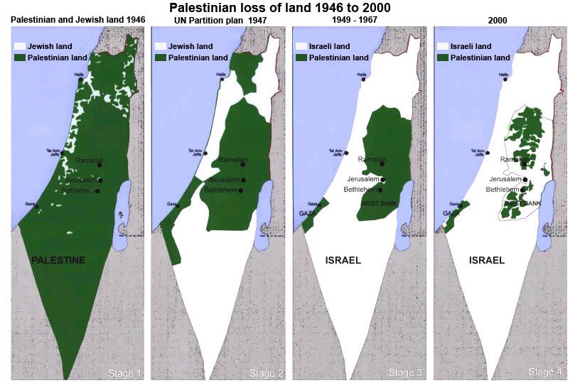
I am of course talking about this map: http://www.juancole.com/images-ext/2010/03/map-story-of-palestinian-nationhood.jpg
It often pops up on facebook feeds and less established online newspaper articles as proof of how Israel deliberately has tried to exterminate the Palestinians for decades.
I have tried reading the FAQ and various online sources. As far as I can tell the first picture depicts a british territory and the second the UN partition. The latter two, if I've gotten it correctly, are the results of annexation following wars not started by Israel?
So what I'm asking is, is there any truth to the allegations of Israel being expansionists, and if so, can this map be considered proof of it?
I have seen this map and similar variations of this map before. The first map is probably depicting private rather than political land ownership. Politically all of the land in the first image is owned by the British Empire in what was known as the British mandate of Palestine. Britain acquired this land and other Mid-Eastern lands from the defeated Ottoman Empire after World War I. France was given Lebanon and Syria, and the British were given Palestine, Jordan, and Iraq. Mandates were basically seen as colonies that will eventually be given independence when it is felt they could stand on their own. During the time of the British Mandate and prior a significant number of Jews made their way to the land. While the first map should show the private land owned by Jewish versus Palestinian citizens. The way private ownership is depicted though is not accurate. All Jews are grouped together though the Mizrahi Jews had been residing there for many years before Theodor Herzl and Zionism began and larger amounts of Jews arrived. Also any land not owned by Jews is simply grouped into Palestinian land. This ignores countless other groups who owned land such as perhaps Brits, Arab Christians, Druze, Bedouins and others. Some land was also not owned at all and was uninhabited. In particular the southern area where the Negev Desert is sparsely populated even today, more so back then. Much of the uninhabited land is grouped into Palestinian land.
The second map is the UN partition plan as you said. The southern land allocated to the Jewish state is the most striking addition and it is because it was sparsely populated that it was given to the Jews as there would be less disturbance of other peoples. The Northern coast was also populated mostly by Jews and or sparsely populated. These were the proposed boundaries for the Arab and Jewish states. The Arab states did not agree to the UN Partition Plan and the day after Israel was declared a state by its inhabitants war was declared upon it by a coalition of Arab states to reverse the Partition. Israel was able to win this war and as a result acquired the land seen in image 3. The war caused large forced migrations of people both Jews and Palestinians. Palestinians in Israel were forced out and so were Jews living in other Middle Eastern states. After the 1948 war Egypt annexed Gaza and Jordan annexed the West Bank. So the land in the 3rd images isn't really Palestinian land but land formerly part of the proposed Arab state annexed into Egypt and Jordan.
Following the Suez Crisis Israel occupied the Sinai peninsula though the Egyptians get it back shortly after. By 1967 tensions were high again and another Arab coalition was gearing up for war with Arab forces on the border. I don't recall exactly recall but I believe a day before the Arabs launch their attack the Israelis launch a preemptive strike. The Israelis win this war and and take Gaza, the West Bank, the Golan Heights, and the Sinai Peninsula. 6 years later the Yom Kippur War began as a surprise attack on Israel to reverse Israel's gains from 1967's Six Day War. The Arabs were eventually repulsed by Israel and peace achieved. Egypt and Israel later write a peace treaty and Israel returns the Sinai Peninsula.
The 4th image is supposed to represent more modern times though it is out of date. Since 1967 settlements of Jewish Israelis have grown in the West Bank and Gaza, some built by more zealous Jews who see it as land reclamation or returning to formerly Jewish lands. Settlements have attracted large amounts of condemnations to say the least though many are now well established. Some have been removed such as settlements in Sinai and Gaza which Israel pulled out of. I found some more recent maps of the are here, here, and here.
So the map portrays actual historical realities, but makes a false comparison.
The first map shows Jewish land vs other land. All land not owned by Jewish groups gets lumped in to Palestinian land, including public land, uninhibited areas, etc. At this point, there's no Palestinian or Israeli political authority.
The second map shows the UN proposal for the partition of Palestine. It was never a factual situation. It also represents hypothetical political bodies, not land ownership. Palestinians would've been a significant minority in the Jewish part of the partition.
The third map goes further off. The area labelled "Palestinian land" was all under the governmental authority of Jordan or Egypt (unlike the 2nd and 4th where "Palestinian land" is a political assessment. Here, the term "Palestinian land" is meaningless, since it counts Jordanian-controlled public land as Palestinian, but not Palestinian-owned land in Israel). Additionally, a non-negligible portion of Israel was owned by Palestinians.
The fourth is the area controlled by the Palestinian Authority. Without going too far into it (20-year rule), it's a political map, not a demographic one, and doesn't represent the extent of where Palestinians actually are.
Previous comments did a good job. The problem is that there is no consistency in what "land" is. Pretty much the only time Palestinians had political control was from '93 on-wards of Area A (and B to a lesser extent) and Gaza Strip, completely, since '05.
As for Palestinians settlements, most of the loss happened during the '48 and '67 war. However, since the Palestinian population in the territories has quadrupled, and we're not even including Israeli-Arabs, it stands to reason that Palestinian land has actually grown since post-'67, but just not legally within Area C since '93 by all that much.
I attempted to make a more accurate labeling of the maps (tweaked GS in 4th a little to reflect Israeli evacuation) with this version.