I am working on a WWII project specific to Operation Dragoon, and in reviewing the period maps for beach 264-A (Camel Green Beach, landing zone for the 36th INF), I see several instances of this map symbol linked below:
However, this symbol is conspicuously absent from the map key, and I'm trying to figure out what it is. It's worth mentioning that several of these have numerals next to them which (I think) usually indicates how many guns are present at [Map Symbol].. Is this maybe meant to show a house with a gabled roof with 'x' amount of [weapon type] emplacements, or something else entirely?
Thanks!
Edit: clarity
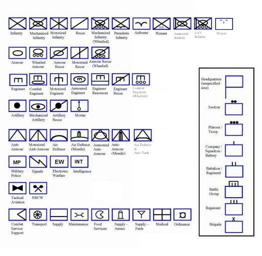
If its actually a unit marker, its probably a maintenance unit. However, It seems suspicious that there is no unit markings, no size, and no unit identifies. For example, this symbol is what I would typically consider to be a unit marker. It is evident, by the information provided around the symbol (as well as symbol itself) that we are looking at the 14th Mechanized Brigade. Your map doesnt include any of this information. Thus, Im suspicious.
Further, lets consider the rest of the map. I cant find any other units, even in the landing zones. Typically, the zones should be capped by a Symbol designating the unit intended to effect that landing. There is none of that. But the map is filled with artillery symbols, and unit numbers for those units. Then you have all that garbage on the beach, which kind of looks like a wall. Finally, there is are those zones, which have lines inside irregular boxes. I think youve mistook one of these for a unit symbol. But, I dont think those are unit symbols at all. Instead, I would think that this is a map of German defenses and artillery units in the area. The red lines along the beach are probably walls and fortified positions, while the cannon looking symbols are batteries. The boxes are hard to identify without proper context, but I would think theyre probably German garrisons, bases, marshalling areas, motor pools, dumps, ect. The number could be number of men, vehicles, buildings under the box, or anything really. Without know for sure what the the box represents, its impossible to say.
But all this is really a shot in the dark without context. If I were you (unsolicited advice inbound) I would try and find out what the map is. Where did you get it? Do you have any other associated paper work? Any similar maps?
I don't have access to any WWII-era field manuals, but the system they used then serves as the basis for what's still used today. Which is to say that it's largely an expansion of what they were doing in WWII, and so a current reference should still contain descriptions for the older symbology.
The current Army Field Manual that details this is FM 1-02, OPERATIONAL TERMS AND GRAPHICS
Chapter 5 details what goes into unit markings. However, I don't think this is a unit marking. Here are my reasons:
It looks like a military map marking symbol. There are a lot of them and they aren't usually shown on the printed map legend as they are added by hand as intelligence reports unit movements, often on a clear talc overlay so they can be amended. In general form, a rectangle, this appears to be a symbol indicating a friendly unit. Unfortunately it doesn't look quite like any standard symbol.
Generally there are indicators above the symbol to show its hierarchical size, such as squad, company, brigade etc, and numbers beside the symbol (left side) to show the unit designator.
The detail inside the rectangle shows what type of unit is indicated. A diagonal cross touching each corner (bandoliers) indicates infantry. The symbol shown MIGHT be a poorly drawn symbol for an Ordnance unit which is the only symbol showing that ridgeline and the projecting prongs at each end although the prongs should not reach the corners of the frame. It can be thought of as a stylised spanner.
There were a number of Ordnance units on Operation Dragoon. Check if any of the numbers next to those symbols match the unit designators for any of the ordnance units.