With politcal map I mean nations, political map is just the term I copy from paradox games.
While certainly a politically developed area by the early 19th century, you will struggle to find a particularly accurate map for the whole of Africa during the 19th century. One of reasons for this is that the continent itself is very large. The political systems in place in west, central, southern, eastern and northern Africa were so vastly different during this period that to place them on a map would be very inaccurate.
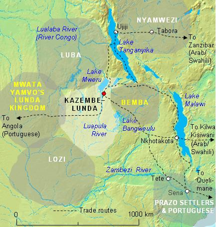
In my area of study, central Africa (between the Congo and Zambezi rivers) often states did not have rigid borders within which a centralized authority lead the affairs of the polity. Commonly seen is a system by which the state had a core area towards centre where a capital would be found which housed a king or chief. Towards the edges of the territory the king claimed as his own the king would have much less power than in his core areas. Outside of this area completely individual villages might be authorities unto their own with no influence from the king.
Furthermore where states bordered one and other there was no clear cut boundary such as one would find in a map of Europe at the early 19th century. There was more a blurred area where the influences of each chief would be contested. Each chief might raid villages or try to coerce them into paying him tribute over his neighbor.
With this in mind I can recommend a few a maps of the areas of Africa that might give you a better visualization of how a map of Africa during the early 19th century at this time. Bear in mind that these do not translate very well to the rigid format of a paradox game. Unfortunately the best maps are under copyright and you'd have to either buy them or borrow them (I don't think I can post copyrighted material in public here). Notably there are a couple of good maps in John Iliffe's Africans that show the states of certain areas. A Modern History of Africa by Richard Reid also has a couple if I remember correctly, I don't have that book to hand at the moment.
This map while pretty basic and nowhere near 100% accurate should give some idea of how the so called borders were not like European states'.
This book, has a few maps in it that can give you a slightly better idea of the states that existed.
On p146 there is a map of Southern Africa. This map shows some more traditional european states (Orange Free State, Cape Colony) Alongside the Tswana African state to the north and the Zulu and Swazi to the east. The borders here are more established because of early colonial treaties between the Boers, British and the Africans.
On p275 there is a map of the great lakes (Rwanda, Burundi, Uganda parts of Kenya) that once again has less defined borders but shows the locations of the states in the area.
p181 there is a map of eastern central Africa, modern day Zambia, Mozambique and Malawi that has the Lozi in the south east giving a little relativity to the map above from wikipedia.
p295 there is a map of the Congo and modern day Angola area. You can also see the Lozi in the south west which should help you place the other map from wikipedia in the perspective of Africa as a whole.
The map on page 4 of this book focuses in even more on the Eastern African area of the Lozi, Lunda and Luba and shows how on a very small scale there are still lots of ethnicities and states that would be very difficult to portray on a large map of Africa.
There are quite a few areas I've missed that have maps in the UNESCO articles might also be of interest to you. Realistically it might be possible to make a political map of Africa in a Google maps style system. However the difficulties in translating the data we have to a map in way that takes into account the intricate differences between states in Africa and the constantly shifting 'borders' would make it a mammoth undertaking.