Navigating into the unknown/without a map is somewhat of a lost art, these days, but there are still resources to help us out here. It should be no surprise that survivalists (there are all kinds, including minimalists who use no maps, no gps, no compass) are modern keepers of some of this knowledge.
A still very relevant work is Harold Gatty's "Finding Your Way Without Map Or Compass" (modern title, originally "Nature Is Your Guide"). Gatty was a celebrated navigator in the first half of the 20th century. His book was intended as a practical resource for navigators, and was published posthumously, only months after his death.
In his book, he describes various ways of "reading" nature. For instance, birds. You KNOW there must be land in the direction in which migratory birds fly. Another method is the reflection of the surface on clouds: deep waters turn the clouds darker than land, which reflect yellow or green on the clouds. Also, land breaks up wind and water currents. By paying close attention to such details, a trained navigator can seem to have almost superhuman abilities.
In the book, Gatty actually talks about the Polynesians AND the Vikings. According to him, the Vikings primarily used birds as their means of finding land, hopping from island to island, while the Polinesians also used the cloud-reading techniques. (Edit: they were masters at reading the patterns in currents. So much so, that their maps represented the patterns in the waves throughout the ocean.)
So, while this is no direct answer to the question of how they prepared and how long they travelled before turning back, this at least gives you an idea of what was feasible.
I hope others here can give you a better answer than I can, but hopefully I have at least given you something to work with.
Edits: some clarifications
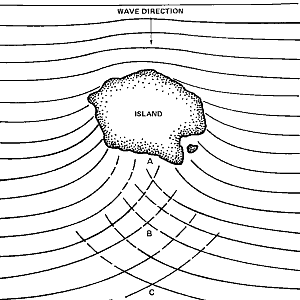
Speaking just for Polynesia: one of the ways to discern land is from wave patterns. Wave refraction causes waves to "bend" around islands which also results in a lot of chop/cross-swell directly behind the island. This is a good example of the pattern. The Polynesians made a lot of navigation maps from sticks and shells to show islands and common swell patterns. Besides using this navigate between known locations, it could be used to infer from swell patterns where other islands may likely lay.
There's also a theory that Polynesians had a specific method of exploring that helped ensure safety. That was either going against the currents/winds or waiting for a brief period of reversed currents/winds to go out exploring so that their return voyage was made much easier.
Another intriguing possibility is proposed in Geoffrey Irwin’s The Prehistoric Exploration and Colonization of the Pacific. Irwin suggests that those who settled Polynesia may have used a deliberate strategy of exploration that allowed them to find islands without an inordinate risk to their lives and with a high rate of survival. (Other scholars have assumed that the exploration of the Pacific was full of danger and involved high casualties at sea.) This deliberate strategy of exploration, according to Irwin, involved waiting for a reversal in wind direction and sailing in the direction that is normally upwind (i.e. eastward in the Pacific) for as far as it was safe to go given the supplies that were carried on the canoe. The return home (westward) would be made easy when the wind shifted back to its normal easterly direction. Irwin believes that this strategy is supported by the west to east settlement of the Pacific, from the islands of southeast Asia and Melanesia to Samoa, Tonga, the Cook Islands, the Society Islands, the Tuamotus, and Hiva (the Marquesas). Although no factual evidence would prove that this strategy of exploration was actually employed by Polynesian navigators, the strategy would have been obvious to anyone familiar with sailing.
From: http://pvs.kcc.hawaii.edu/ike/moolelo/discovery_and_settlement.html
Could someone please answer the question on how they re-supplied themselves?
I'm really sorry I haven't been more active in this thread, it is a specialty area, but I've been putting out fires at work all day (not literally).
Here is a similar question from awhile back that /u/davidaop and I contributed to -- we have similar historical interests. It may be of some use to you. I apologize I haven't been able to contribute further, though.
Greetings prospective respondents!
just a reminder to answer the question. OP is not asking who thought the world was round, or how various cultures navigated (these topics have been well covered in this sub - run a search if you want to know more about them): OP is asking about the plans and strategies these famous seafaring cultures had for dealing with long voyages.
Another reminder to review the rules for answer quality; TL;DR:
Answers in this subreddit are expected to be of a level that historians would provide: comprehensive and informative. As such, all answers will be assessed against the standards of Historiography and Historical Method.
I'm assuming you are speaking specifically about voyages of discovery here, not voyages of trade or war.
In the case of the Early Medieval Norse (technically they weren't Vikings if they were not on a plundering expedition) the answer is simply that they didn't do any discovering.
But wait, you might say, didn't they discover America? Yes, they did, but by accident. This was never a case of someone setting out to see what is behind the horizon it was a simple case of someone trying to reach Greenland but being blown off course. That someone, Bjarni Herjólfsson, sighted land but didn't set foot on it. He later told others who set out to explore this country under the leadership of, you guessed it, Leifr Eiríksson. So the people who "discovered" America already knew what they would find!
Half a generation before them it was the same story: A man, Gunnbjörn Úlfsson, was blown off course when he tried to reach Iceland from Norway. He saw some islands but didn't land on them. Shortly thereafter settlers set out from Iceland. Among them Leifr Eiríksson's father Eiríkr inn rauði, Eirik the Red, who later decided to call that newly found land Greenland.
I can't think of any example where the Viking Age Norse set out for a voyage of pure discovery. Usually they had at least a vague idea where they were going and what they would find there.
Thank you for taking the time to answer! I really enjoyed reading them.
hi.. just ran into this old post which may be of interest
How in the world did vikings sail from Scandinavia to Britain in longships with no way of shelter?