I found a very interesting map over here: http://geacron.com/home-en/
It basically maps all states and empires from the last 5000 years, which is quite impressive.
Now I know it's probably impossible to make an accurate map, because of lack of information and probably in some cases difficulty of labelling correctly.
But I was wondering if there are any obvious errors that you could see, probably from your field of research or other knowledge that you have about this topic.
Looking at my own neck of the historical woods, this map is woefully inaccurate. I'll just hit some highlights because I could be at this all day if I really invested the time.
There's no Old Copper Complex around the western Great Lakes (which would have been there from the map's start date until ~1000 BC). There's no Poverty Point Culture in the lower Mississippi from 1700 BC - 700 BC. The Mississippians show up way too early (around 800 BC, when they shouldn't show up until around 1000 AD, maybe 600 AD if you're including the various proto-Mississippian cultures like the Coles Creek Culture). You don't get a real sense for the extent of the Adena or Hopewell Traditions when they pop onto the map (the key is cut off the linked map, so a quick run down, the darkest brown is the earlier Adena culture, with their sites marked with orange squares. The next darker shade are the various local manifestation of the Hopewell Tradition, with their sites given their own unique icon. The off-white is the region influenced by or trading with the Hopewell, but not actively participating in most definitive cultural traditions). Also the Hopewell strangely show up in New York first while the Adena simultaneously vanish. In actuality, the Havanna Hopewell would be the earliest practitioners of those traditions, and from Illinois it would spread into Ohio where the majority of Adena picked it up and ran with it. But a healthy population of Adena traditionalists kept on going for centuries after this in southeast Ohio and neighboring West Virginia.
Also, around 900 AD, the Iroquois pop into southeastern Ontario out of no where. It's not inaccurate for Iroquoian people to be there at that time, but the people we know as the "Iroquois" weren't. They were in western New York. The Iroquoian heartland is the mountains of Pennsylvania, but around this time, they began a decisive push north, with some earlier migrations heading south to become the Cherokee. Another important migration that began about this time is the Anishinaabe migration westward from the coast, following the St. Lawrence into the Great Lakes.
By 1400, things are starting to look a little better. The Iroquois are properly placed, with their Huron counterparts immediately to their north. Absent, however, are other Iroquoian nations in the surrounding area and all along the St. Lawrence. The Cherokee on are the map now along the upper Tennessee River, but this too far south for them at this time (to the extent that Cherokee existed as a social identity at the time). Similar things could be said for the Shawnee, who are now on the map in western Kentucky. To the extent that a 'Shawnee' identity existed in 1400, it should be in northeast Kentucky and southwestern Ohio in what was the Fort Ancient Culture at the time. Speaking of which, the Seminole and Comanche are both on the map now, both a couple centuries too early. In 1400, neither had branched off their parent cultures yet.
Absent from the map at this time (and for the next century or so since this region doesn't seem like it changes until Europeans show up) are the various dominant Southern Mississippians that should be occupying the space given to the Choctaw, Seminoles, and Cherokee on the map in the 1400s and 1500s. We should see Coosa at the very least, which ruled a 400-mile long domain through the southern Appalachians where the map places the Cherokee. But no. And that's just the tip of the iceberg when it comes to missing polities that could be on this map in the region from Contact onward.
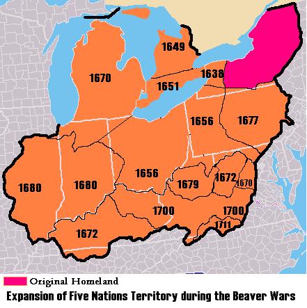
Going back to the Iroquois for a moment, when 1650 hits you'll see the Huron shift to the northwest. This is the start of the Beaver Wars and the huge territory expansion of the Iroquois. But unlike their European counterparts, whose territory painted across the map with bright colors, the Iroquois (and all the other indigenous nations for that matter) just briefly pop up as an ambiguous label. The decision to present the information in this disparate way has some unfortunate, and probably unintentional, implications - namely devaluing indigenous land claims in favor of imperialist powers. It presents the bulk of the Americas as virtually empty land waiting for some explorer to plant a foreign flag on it.
I am Indian, I tried map for every 100 years, basically Indian subcontinent always had at least 500 kingdoms in given point of time in last 1000 years. But all i see is some 5 or 6 kingdoms which are famous are listed.
But Indus valley is suddenly appears 2500 BC as largest civilization in 10 years. Before Indus there was saraswati Valley civilization which spread to form Indus valley , which is not mentioned.
There is no such thing called Indo Aryan, Its just plane Aryan that means noble, not race, Its like aristocrat , Thats not race but title to people, Aryan as race is misconstrued by Europeans. Due to exsessive use people came to known as aryans to outside people, that mean they are not single race but you can call a civilization, And there was no separate dravidian divide.
I am not sure about other countries.
No Nyasaland? It just goes from blank to Rhodesia to Malawi.
You will forgive the wikipedia link, but this diagram roughly indicates the evolution of the Rhodesias and Nyasaland into Zimbabwe, Zambia, and Malawi.
http://en.wikipedia.org/wiki/Nyasaland#mediaviewer/File:Rhodesia_and_Nyasaland.png
A fairly minor thing, but Algeria transitions from being controlled by the Ottomans to the French all at once in 1830. While the French invaded in 1830, the Ottomans weren't totally driven out until 1837.
Just took a pretty quick look. It has British settlement in Australia beginning in 1789. That's off by a year. British settlement began in 1788.