It sounds like a ridiculous question but I live in Michigan and we have a few old rail lines and a handful of roads that supposedly follow old logging trails which purport to follow old "Indian Trails" (I believe Mound Road is a throwback to an Indian trail that ran abrest to burial mounds, hence the name, but idk. Seems dubious)
The thought just occurred to me that I don't know if any Native Americans made roads, either Native North Americans or Native South Americans. Like I said above, I've heard of "trails" but I guess I imagine a beaten path through the woods that follows natural terrain and is not what you would think of as a road.
Did any native americans make roads? If so - are any still around?
Standard disclaimer: "Native Americans" covers two continents and thousands of years of history, yadda yadda yadda.
But to answer your question, yes, Native Americans certainly made roads.
There are of course, many different kinds of roads, ranging from simple footpaths to large, paved highways. I assume you're only interested in the larger, "formal" roads which we would recognize as such today.
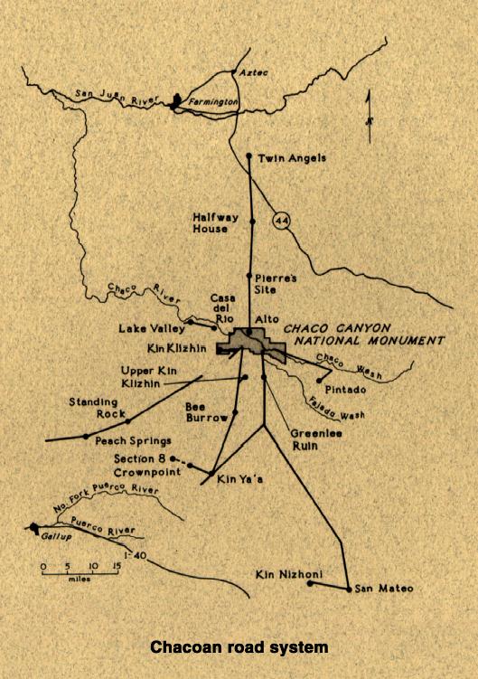
One of the most impressive road systems north of Mexico is at Chaco Canyon. A massive network of built roads connects multiple archaeological sites in the region, fanning outward in a dendritic pattern from the canyon itself. The roads are quite impressive, in some cases they can be up to 9 meters wide. They're built up to go over dips in the landscape, and in places cut through hills much like modern roads do. The exact purpose of this road system (whether it's purely economic, political/militaristic, or ritual in function) is largely disputed, although it likely served a combination of such functions.
Within Mesoamerica, paved roads were quite common although they are usually restricted to within cities. Causeways were constructed through a gradient of materials, by placing large boulders on the bottom, slightly smaller stones on top of that, smaller ones on that, and gravel on top. In regions where lime plaster was available in sufficient quantity, the surface of these roads may actually be paved in plaster. In other areas sand or clay were likely used to top the roads off. Mesoamerican roads are very diverse, sometimes they conformed to the local topography, cutting switchbacks up steep inclines and winding around mountainsides. In other instances, like at Teotihuacan for example, roads formed a more rigid grid-like pattern that was imposed onto the landscape. While formal roads between sites were relatively rare in Mesoamerica, they were not unheard of. In the Aztec region, a maze of roads and canals cut through the capital city. Roads frequently formed causeways passing over bodies of water, and connecting islands to the mainland. A highly impressive road system can also be seen at the Maya city of Caracol, where a series of elevated limestone causeways connect the city to its satellite communities.
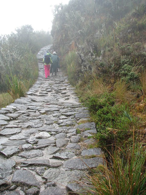
Of course, the most famous road system in the Americas were the Inca highways. The Inca created a road system that connected their capital to major centers throughout the empire. The Inca highways were often built up. Sometimes they were paved, but often they were made of packed earth. Suspension bridges allowed roads to cut across steep canyons and staircases were used to traverse steep inclines. What makes the Inca road system most impressive, however, is its scale. The Inca had a network of highways that essentially spanned the entire length of South America. The roads were used by state officials, and locals often needed special permission to use them. Storehouses containing food and supplies existed at regular intervals along most of the highway network, and could be used by messengers or other Inca officials for long voyages.
As for your other question, many of the roads I've described here are still around and you can go walk them today, but many are also overgrown and have fallen out of popular use.
But yes, Native Americans definitely had roads.
Sources:
Trombold, Charles D. (editor) 1991. Ancient Road Networks and Settlement Hierarchies in the New World. Cambridge University Press.
R. Gwinn Vivian 1997. "Chacoan Roads: Function" In Kiva 63(1.) pp.35-67
While many of the trails in the Eastern Woodlands are relatively narrow - just wide enough for a single person, or occasionally wide enough to accommodate a small European cart when they were introduce (or a hand-travois before that), a some of the more heavily traffic trails were broader still. De Soto's entrada traveled along paths broad enough for them to be called roads in the Spanish's eyes, and for the army to surround and escort a Native delegation that had come to greet them while they traveled (so something wide enough for 4 to 8 people to walk abreast - de Soto's chroniclers were specific about the formation they marched in). Regardless of their breadth however, the most important trails were carefully selected and, to a certain extent, constructed. Three criteria were important in the creation of such trails: directness, levelness, and dryness. Individual trails were crafted in a balancing act of these three priorities and often multiple trails, each with their own strengths and weaknesses were created to suit various travelers (see this post in a related topic for an example of these complementary trails).
As mentioned, these trails weren't merely beaten into the forest unthinkingly, and we know historically and archaeologically that effort was put into making them. For example, Nemacolin's Path through southern Pennsylvania was a joint Anglo-Lenape effort to improve an existing trail. While it was commissioned by the English, it's main architect was, unsurprisingly, Nemacolin. Another example occurred before the American Revolution (I'm forgetting the exact year at the moment and my searches right now keep pulling up a later incident in 1813 when this path was upgrade to accommodate wagons): the Creek Confederacy upset the British in Charleston because they had created a new path connecting their towns in Georgia to the Spanish trading outpost in Pensacola. Perhaps the most elaborate road in the Eastern Woodlands is the ancient (circa 250 CE) Great Hopewell Road, that ran presumably ran the 60 miles between Newark, OH, and Chillicothe, OH - the two major ceremonial centers of the Scioto Hopewell. This road was 200-feet across and flanked by embankments. You can see the beginnings of the road in this survey of the Newark Earthworks as the "Parallels 2 1/2 miles long." Since that map was made, another 10 continuous miles of the Great Hopewell Road has been confirmed and there's scattered evidence for it here and there on the way to Chillicothe, but it has been heavily erode over the centuries and is difficult to discern.
Over all, the Eastern Woodland trail system was incredibly extensive (still is, when you consider that many US roads today are merely modernized versions of the pre-existing trail system), as this map of the major southern trails show. Many of these trails heading north eventually reach the Great Lakes and the St. Lawrence River and, after crossing portage and fords, link to trails reaching all the way to Hudson Bay and the Arctic Ocean. The paths heading west, after linking up with the roads of the Southwest and the trails crossing the Plains and Rockies, eventually reach the Pacific.
Speaking of the Southwestern roads, this map shows the local roads linking the various communities of Chaco Canyon, the major Ancestral Pueblo center at the beginning of the second millennium. This map zooms out a bit more to show the roads radiating out from Chaco Canyon through the rest of the Southwest. The transit system represented by these roads extends southward to Paquime, just south of the US-Mexico border, and from their connects to the trading network of Mesoamerica. You can read more about the Chacoan roads and see a picture of what one looks like today at the Chaco Culture National Historical Park's site.
A final thing I should mention falls a bit outside the literal reading of your question, but I feel it'll be of interest to you. At the time of European contact, most of southern Florida was under the control of the Calusa - either directly or thorough a subsidiary polity. To ease travel their marshy domain, the Calusa constructed numerous canals. While 300 years of neglect have allowed the Everglades to consume these canals again, this artist reconstruction of a Calusa canal under construction should give you an idea of what they were like. You may also be interested in this video concerning the canals and the discovery of one in Naples, FL.
The Chaco Canyon culture in northwestern New Mexico built fairly impressive roads using impressive materials brought in from elsewhere and renowned for their straightness. Supposedly, they reached 180 miles long and 30 feet wide which has always seemed bizarre to me for that landscape and considering they didn't have carts, beasts of burden, or a particularly large population. For a number of reasons, it's believed the roads may have been largely ceremonial in purpose and not used for everyday travel or linking communities and resources.
The whole Chaco Canyon site is impressive and somewhat of a mystery still, if you ever get a chance to wander up there you should take a look.
Even some modern roads owe their origin to Native American roads. For instance, the "Mohawk Trail" is a scenic highway that begins in Western Massachusetts and follows the original path of a Native American trading route.
Many highways and even parts of what have become the Interstates follow the original route of the Seneca Trail which crisscrossed Eastern North America and is extensively documented in historical texts.
This makes a lot of sense if you just think about it. Especially in the Appalachians, a good gap to cross the mountains is important for people walking or people driving. A good gap is a good gap. Native Americans traded extensively across the continent prior to European arrival, as finds of things like Obsidian from Yellowstone and Mexico in burials in the Woodland cities around what is now St. Louis show. Goods were making their way from South America to North America for thousands of years before Europeans showed up. There were absolutely roads and trading paths established for that, as well as for moving troops in times of conflict.
Just FYI I am a NA archaeologist and MA resident
Regarding original trail routes through Michigan, yes, they were common. I don't know the name of the trail that passed by the burial mound for which Mound Road is named, but the mound was there - it was located just north of 8 Mile Road - it's under the I-696 intersection (according to one source in a casual conversation) or according to the Oakland County Pioneer and Historical Society, in the median of Mound Road.
There are several old trails throughout the area, the most well known is probably Dixie Highway, running from Toledo up through Detroit and Royal Oak, to Pontiac to Flint and points further north - this was originally called the Saginaw Trail by European settlers and was originally created by the Sauk. Woodward between Pontiac and Detroit follows the route of the trail.
You can read quite a lot about these trails in this book: Archaeological atlas of Michigan [by] Wilbert B. Hinsdale, published in 1931. Author: Hinsdale, W. B. (Wilbert B.), 1851-1944. Source: http://quod.lib.umich.edu/g/genpub/1265156.0001.001/11?page=root;size=100;view=image
Trails are discussed starting on page 3.
Yes, some Native American tribes did have certain paths that they followed when traveling, but most would not be considered roads and were not obviously marked, although many would later become roads. (Skip down for a list of trails)
Native peoples traveled for many reasons, but most tribal members traveled for these two distinct reasons- 1) To get staple foods and/or find safer areas. 2) To perform religious ceremonies or celebrations. For example, the Northwestern Coastal tribes sent their men on annual trips to nearby rivers during salmon runs (food), and sometimes traveled to nearby lands to attend potlatches (ceremony/celebration) [Mark Sutton, An Introduction to Native North America 3e, pg. 131-134]
Therefore, virtually every Native American trail founded on the migration path of a source of food, or made to be traveled with ease.
LIST OF NATIVE AMERICAN TRAILS THAT PREDATE THE U.S.A.
-Located in the Cumberland Mountains of the Appalachian Chain
-Originally a natural passage caused by erosion, possibly a dried stream bed
-First mapped (and named) by Dr. Thomas Walker in 1750
-Became known as Wilderness Road after the Transylvania Land Company commissioned a group of men, lead by Daniel Boone, to widen a path in 1975
-U.S. Route 25E passed through the gap until 1996
[Carl Waldman, Atlas of the North American Indian, pg. 179]
[Rickie Longfellow, The Cumberland Gap, http://www.fhwa.dot.gov/infrastructure/back0204.cfm ]
-Also called Nemacolin's Trail
-Crossed through the Allegany Mountain Range
-Named after a Native American Chief that was hired to find/map/blaze the path in 1752
-Utilized in various war campaigns
-Became one of the first highways in the country, U.S. Route 40
[Carl Waldman, Atlas of the North American Indian, pg. 179]
[Daniel Murphree, Native America: A State-by-State Historical Encyclopedia Volume 3, pg. 1242]
3)Bald Eagle Creek Path
-Named after an unknown Lenape Chief
-Possibly used/established by Iroquois tribes
-Now defunct, but portions of the path are still used in roads and highways
[John Meginness, History of Lycoming County, Pennsylvania..., Chapter 2 - Heading #6 "Indian Paths" http://www.usgennet.org/usa/pa/county/lycoming/history/Chapter-02.html ]
[Paul Wallace, Historic Indian Paths of Pennsylvania 4e, pg. 23]
Located Northwest of Roanoke, Virginia
Partially connected to the Great Indian Warpath
Became the basis for a now-defunct rail line
[Jim Hargan, Explorer's Guide: The Shenandoah Valley & Mountains of the Virginias, pg. 374]
[Michael Pulice, National Register of Historic Places Inventory/Nomination: Foster Falls Historic District, pg. 7, http://www.dhr.virginia.gov/registers/Counties/Wythe/098-5141_Foster_Falls_HD_2009_NR_FINAL.pdf ]
A couple of observations about Indian trails, which I'm frequently discussed as the predecessors of (most of) Chicago's diagonal streets:
First, they were footpaths that usually left little imprint on the land, and changed often to avoid a muddy spot or fallen tree. So for the most part, the only ones we know about are the ones that were widened and confirmed by the wagon traffic of early settlers.
Second, as any hiker knows, trails naturally diverge and reconverge. Some were impassable in wet weather; others were deliberately routed past outlying settlements or lodgings. This is particularly evident on the trails that followed high ground on eskers left by retreating glaciers and sandbars left by the receding Lake Chicago. So the “Green Bay trail” followed a number of routes between Chicago and Waukegan, routes that we today know by name as completely different roads.