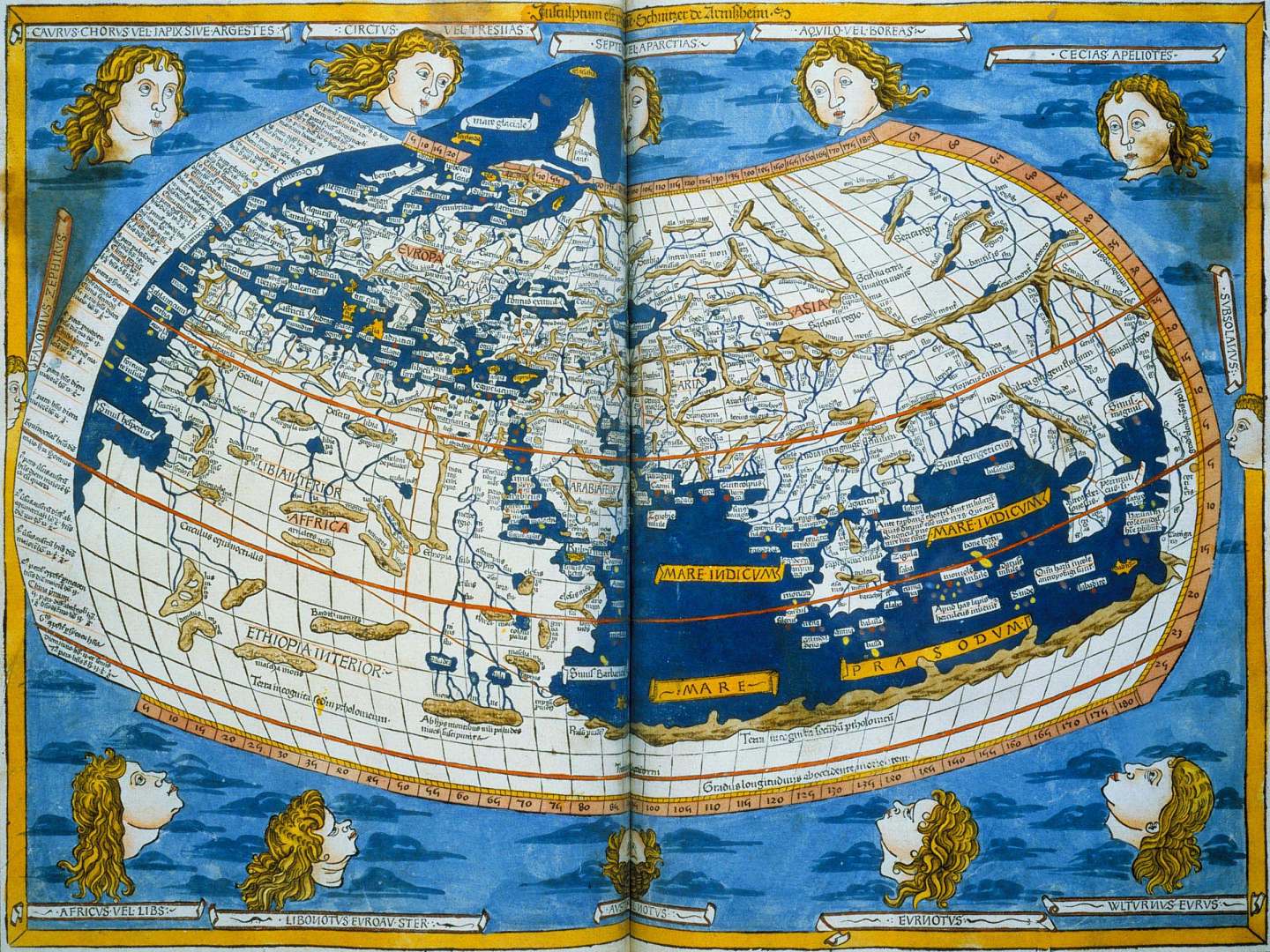
I'm asking more geographically. They knew the earth was round but did they ever try and guess what the land looked like?
hi! not discouraging other responses here, but fyi, you may find this section of the FAQ interesting - it contains several comments on Roman geographic knowledge.
So I had a much longer comment typed out (yeah, I know), but this thread and this one do a fairly good job summarizing most of what I had to say, so I'll keep it shorter. I'm also going to stay closer to summary than I would like, simply because analysis of all the works I will cite would be more than the scope of a graduate thesis. If you want a go-to author, by the way, I cannot recommend Oswald Dilke enough - he's accessible and brilliant.
The short (!) answer is that Romans had a good sense of the distances between places around them, but not so much of how the land might look from above. For immediate areas of importance (like Rome), they had well drawn-out maps, but these were less important for greater areas. Any student of this subject will immediately object to my characterization, since Greco-Roman maps of this area (to the extent we know of them) were actually pretty good - but relatively speaking, knowing the theoretical shape was simply not as important when you stayed on roads.
1. The map of Ptolemy (stylistically reproduced here) is often cited as an early map, and shows up in both of the threads I linked above. The problem with it is that we don't know how accurate it is (citing Dilke in History of Cartography and Florian Mittenhuber in his "Tradition of Texts and Maps in Ptolemy's Geography"). Ptolemy includes a set of coordinates of different locations around the Mediterranean. These have probably been faithfully copied from the original. But the first maps from Ptolemy's work that we see show up in the 12th century - around the same time that many of these maps were appearing in Europe. Scholars can't decide whether Ptolemy drew that map, one of his contemporaries did, or whether it was a scholar from centuries later - evidence exists to support all three. But Ptolemy certainly had an idea of where various locations existed in relation to the curvature of the earth - hence the coordinates.
**2.**My next example is more for my personal amusement, but the following is an excerpt from Tacitus' Agricola concerning Ireland:
"...Agricola posted some troops, hoping for fresh conquests rather than fearing attack, inasmuch as Ireland, being halfway between Britain and Spain and conveniently situated for the seas round Gaul, might have been the means of connecting with great mutual benefit the most powerful parts of the empire. Its extent is small when compared with Britain, but exceeds the islands of our seas. In soil and climate, in the disposition, temper, and habits of its population, it differs but little from Britain. We know most of its harbours and approaches, and that through the intercourse of commerce."
(For the classicists among you, Book 1.24: "...Hibernia, medio inter Britanniam atque Hispaniam sita...")
Tacitus is telling us that Ireland is halfway between Britain and Spain. We know this to be false, but pay attention to the rest of the passage: Tacitus knows its climate, its rough size, the rough demographics of the population. These were the things that were important to Roman scholars, less so the exact positioning of a place. I will say that I'm cherrypicking a bit - Agricola was one of the first to really interact with Ireland, and the island was much less known than other parts of the world. Point still stands.
3. This is already way too long. Only a few more. The Map of Agrippa is a less known but extremely important piece of evidence - Cortesao (History of Portuguese Cartography) calls it the most important map in Roman cartography. Crone (Maps and Their Makers) says it was the inspiration for the Hereford mappamundi. Sounds great right? Too bad we don't have it, or any copies of it, or really any account of what was on it aside from a few notes from Pliny. Sorcha Carey (Art and Empire in the Natural History) gives a great summary of Pliny's contributions, and concludes that the map was either circular or rectangular, carved or painted, and was maybe huge (running the entire length of the Porticus) and maybe just big (taking up a massive square in the center).
Carey goes on to cite R.K. Sherk's Roman Geographical Exploration (which I unfortunately have not read - if anyone has, please chime in!), arguing that maps existed in Rome before this but merely on a regional scale. To this end, Carey cites Livy (who describes a tablet in the shape of Sardania set up by T. Gracchus after a victory) and Varro (who mentions a representation of Italy on the wall of a temple). The Map of Agrippa, however, was unique in its scope. Returning to my thesis, I must note that the purpose of this map was to encourage trade the establishment of colonies - this is why Augustus gave Agrippa the task in the first place. So the representations of land, while impressive, would not have been as important as the distances that accompanied them (which Pliny tells us the Map of Agrippa had). For a final wrench in the works, Claude Nicolet argues (Space, Geography, and Politics in the Early Roman Empire) that Pliny never even saw the map at all, and instead was consulting the text of someone who had seen it. Welcome to the field of Classics.
4. Ugh, I'll wrap up. The Peutinger Map and the Antonine Itinerary are my final works for you, and they really kind of drive home my point. The Antonine Itinerary was, simply put, a massive collection of distances between locations. That's it. How is that a map? Well if we consider my premise, that Roman mapping consisted of trying to determine the distances between locations, then one could almost argue that a list of road mileage was, in fact, a map. You might argue that a map must be somehow represented as a pictures. This brings us to the Peutinger Map. First, the resources:
This is the best high-def cite for the Peutinger map.
This is Wiki's scrollable copy of it.
And this is my favorite of all time - it lets you use the peutinger Map as if it were Google Maps, which is what the tool was basically for. I've plugged in Avignon to Alexandria as an example, but it's really fun to nerd out with.
So what was the Peutinger Map? It was a massive scroll that showed distances between locations, and showed those locations with pictures. If you turn your head kinda funny you can almost see Europe. But rather than lecture on the meaning, I'll turn the question back on you, OP: Based on my previous points (the actual artifacts I've mentioned), what do you think the Peutinger Map shows us?
I would argue, along with Talbert, that it shows us a grasp of the world in terms of relativistic distances. Elliot's New Windows on the Peutinger Map argues that we're wrong, and that the Map is meant to be more of a reference for mountains, rivers, and shores than a traveler's guide. Harley's Iconography of Landscape argues that we're all idiots because maps are really just symbols (this is a gross over-simplification of his thesis).
Closing notes: For anyone who wants a fun trip, look up the Forma Urbis Romae to get a sense of what Romans could do when they really felt like it. It's a massive scale model of the city from a bird's eye view. My point in this post was not to argue the Romans were not advanced enough to make maps - measurement of absurd distances was a cultural strength. It's just that the length of roads was far more important than say, the width of a random peninsula at a random point - unless you wanted to make a road across it, in which case you could have a surveying team there faster than you could say "Romanes eunt domus." Hopefully this has been a somewhat cogent post - I tried to include too much in too small a space, but this should give you a sense of an answer.
Last treat: Speaking of funky maps, here's one from the "Book of Curiosities. That's Europe at bottom right.
Tabula Peutingeriana. This maps roads from India to Spain.