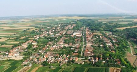
This might be a bit of an obscure question, but look at any small village in the Hungarian part of the former Austro-Hungarian empire, and you'll notice that most of them are quite similar: the houses are placed along long roads without a lot of branching, and the houses themselves are really long and narrow with an equally long and narrow backyard. Here is an example from Slovakia, but you could find the same type of village in Hungary proper.
Meanwhile, the villages in the Austrian part of the empire (like here from the Czech Republic) don't have those features. Wider plots, less narrow houses. Why this difference?
It was orchestrated by Austrian authoritiy during 18th century most notably by Maria Theresia.
After the end of Great Turkish war in 1699 area was resettled by colonists. But the problem was that people have formed really small villages or often have lived alone far away from their neighbours. This was not acceptable to authorities, because it was harder to control and tax such places.
So during 18th century authorities built long roads between cities and encouraged and sometimes ordered peasants to build houses along them and also to construct in accordance to urban plan whose effects you can see in those photos. In my tounge we call it ušoravanje, best to translate it as roadification. So in sense most of those villages are planned and they are common occurrence in areas liberated by Great turkish war.
This is Tovarnik, best example of such process. http://arhiv.braniteljski-portal.hr/files/images/tovarnik-.clanak.jpg http://www.znet.hr/wp-content/uploads/Lovas-www.tnl_.hr_.jpg
My sources(articles) are in my native tongue so apologies for that.
Prilog poznavanju prostornog planiranja ruralnih prostora/sela u Hrvatskoj od sredine XIX. do sredine XX. st., 1999 Jasenka Kranjčević
Procesi urbanizacije sela u Slavoniji i Vojvodini, 1976. Milan Benc