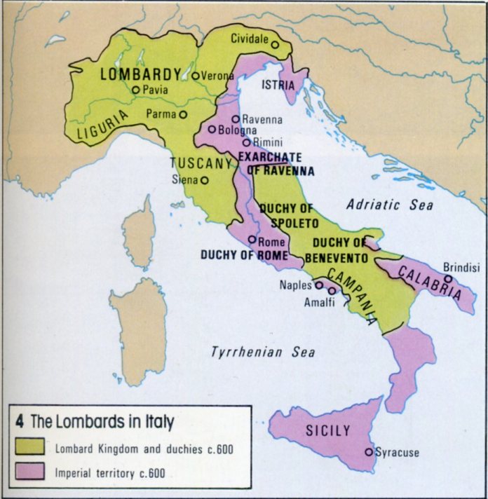
Did the Lombards keep their southern provinces supplied by sea or was the Byzantine "march" more porous than I'm picturing it?
In circa 600 Europe, maps have a little bit of difficulty portraying the reality of political power and geography without contextual background. Power and centralization were a lot more fluid and fractured back then. Just because the map gives Lombardy that yellow color doesn't mean the Lombards had complete control and coordination in that area. You'll also see titles that aren't usually associated with earlier Imperial Rome (Duchy, Exarchate), because due to the serious blows to the Roman Empire they were also forced to decentralize some authority in their peripheries. There was varying degrees of unity and cohesion between local rulers. At this point in history, Europe was more about nation states made up of peoples, the Franks, Alemanni, Suebi, Lombards, Visigoths etc. It was less about a nation state being made up of physical territory, the Kingdom of France, England, etc. That map delineates the areas in which the Lombards had conquered and subsequently governed parts of Italy, meanwhile The Byzantines/Eastern Roman Empire/ or just Romans still reigned over a few important coastal cities and a stretch of mountainous interior.
How did this happen? A little history first, Odoacer and his confederation usurped what was left of the Western Roman Empire. A little after, the Ostrogoths defeated them and seized control of Italy. Then shortly after that, Justinian sent Belisarius in the Gothic War to reclaim Italy, which worked. Then come the Germanic Lombards, defeating the Eastern Roman Empire and carving up Italy leading to the map you see now.
How did this work? The Lombards just weren't powerful enough to fully remove Roman hegemony from Italy, although they slowly did take more territory from them. Even though they were stable, it was still more of a geographical area designated by the people who ruled it, not the people who inhabited it, or by contemporary understandings of nation state legal borders. The United States is always the United States, even if the entire population became French overnight. However, back then, if that were to happen, the United States would be understood to become something different entirely. This resulted in the two regions delineated in the map, Langobardia Major and Langobardia Minor to be a unified culture but not necessarily a unified state. The map says it is all part of the Lombard Kingdom, but that doesn't mean the Duchies to the South were of one purpose. The duchies to the South were part of the Kingdom, but they were granted degrees of independence due to distance and necessity to rule, which were some of the foundations of how we mostly understand feudalism - a hierarchy or web of obligations and duties.
Sure the Lombards had trade between there possessions, and even between the Romans. However, Langobardia Major didn't necessarily need to supply the South, they were settled, permanent holdings that lasted hundreds of years. That 600AD map wasn't the final borders either, as the Lombards actually DID slowly chip away at the Roman lands. The Lombard King's powerbase was in the North, in the regions of Pavia and Lombaria (guess where the name came from). The South was governed mostly militarily. The Lombard duchies in the South actually outlasted the Lombard powerbase in the North! Charlemagne shattered the North in the late 700s. The Langobardia Minor would last until the mid 1000's when Robert Guiscard and the Normans would conquer them.
Most of the sources come from Paul the Deacon and Gregory of Tours, and the annals and deeds of Justinian and Belisarius.