Is is purely arbitrary, or is there a geographic reason?
This is a two-part question. As an American, my first part of the answer will focus on how an American Territory becomes a state. The second part of this response will then focus on how our Canadian brethren handle the same question.
According to the United States Constitution, "New States may be admitted by the Congress into this Union; but no new States shall be formed or erected within the Jurisdiction of any other State; nor any State be formed by the Junction of two or more States, or parts of States, without the Consent of the Legislatures of the States concerned as well as of the Congress." This means that America's Congress gets to decide how to create new states from the territory the country acquires. Broadly, states must meet a minimum population threshhold, elect a government, and apply for statehood. This is how territories like the Louisiana Territory eventually became states like Louisiana, Missouri, Minnesota, North and South Dakota, Kansas, Nebraska, etc. For more information on how the states in the American West got their shapes, I highly recommend the aptly-named "How the States Got Their Shapes." It's a book and also a History Channel series available on Netflix.
Now onto the Great White North. The Constitution Act of 1871 sets forth the following rules:
The Parliament of Canada may from time to time establish new Provinces in any territories forming for the time being part of the Dominion of Canada, but not included in any Province thereof, and may, at the time of such establishment, make provision for the constitution and administration of any such Province, and for the passing of laws for the peace, order and good government of such province, and for its representation in the said Parliament.
The Parliament of Canada may from time to time, with the consent of the Legislature of any Province of the said Dominion, increase, diminish, or otherwise alter the limits of such Province, upon such terms and conditions as may be agreed upon to by the said Legislature, and may, with the like consent, make provision respecting the effect and operation of any such increase or diminution or alteration of territory in relation to any Province affected thereby.
According to Statistics Canada, Ninety-seven percent of Canadians live below 60th parallel, the circle of latitude 60 degrees above the equator. Seventy-two percent of Canadians live within 150km of the 49th Parallel, which forms much of their border with the United States.
Why is this important? Well, Canada drew the northern border for their western provinces at 60^o N. So that's why the Canadian Provinces are so tall compared to their American cousins. There's simply fewer people, and a lot of empty space. As for their width, most western. provinces are bounded by a meridian (e.g. 110^o W and 102^o W for Saskatchewan)
TL;DR: American states may apply for statehood once they hit certain population thresholds. 97% of Canada's population lives below the 60th parallel, but 72% live within 150km of the American border, so the provinces end at 60^o N and their internal borders are marked by lines of longitude rather than natural geographic features.
They didn't start that way.
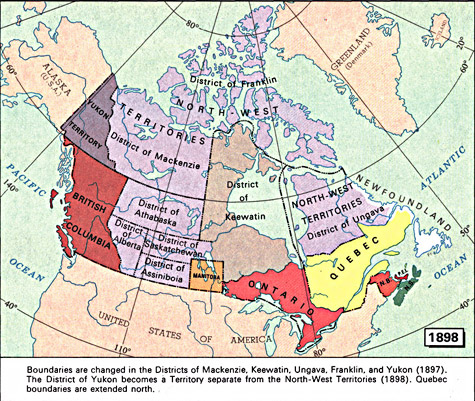
Manitoba, Saskatchewan, and Alberta were all significantly smaller in their original borders, as can be seen in this map showing 1898 boundaries.
British Columbia was also smaller originally, as can be seen in this map showing districts in 1862, in which the north and Vancouver Island were distinct colonies (Queen Charlotte Is. too, I think), and the northeast was still part of the N.W.T.
Since the north is very sparsely settled, it made more sense to extend provincial jurisdictions northward than to wait until enough people showed up to make a new province.