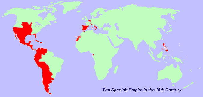
One thing I've noticed when looking at maps of the Spanish Empire is that the highlighted areas strike me as...somewhat exaggerated. They quite obviously didn't control the whole Pacific American coast in the same way that they controlled areas like say, Cuba or Mexico, even at their height.
I haven't encountered a map that's actually made any type of distinction between what they simply labelled as theirs and what they had actual, enforceable authority over however. Is there any scholarship or archeological study on the matter?
It is curious that these maps continue to be produced even though we have a very good idea of what territory was under direct administrative control of Spain and what was not.
Two of the most egregious examples are from the 16th and 17th centuries in Central America and in New Mexico.
In Central America, a number of Native polities remained independent of Spain until well into the colonial period, but these are rarely marked on a map. For instance, while the highland Pacific areas of the Maya region as well as the Gulf coastal areas came under Spanish control fairly early on, the interior of the Maya region (southern Mexico/Guatemala) held a number of independent states well into the colonial period. Most famously, the Peten region where the Maya kingdom of Itza remained independent until 1697!
Likewise, New Mexico in the 16th and 17th century was only partially under Spanish control despite most maps portraying the entire US Southwest as a part of Spain. In reality, Spanish control only really extended to the sedentary, agricultural communities of Pueblo people along the Rio Grande (including a few not on the river, like Acoma and Laguna Pueblos). While not a great map, this gives you an idea of what actual control was like. You can see the greatest density of Pueblo villages was along the Rio Grande from Taos in the north down to Socorro in the south. Nominal control extended West all the way out to Hopi, but consistent control only really extended to Zuni to a degree, and really only out to Acoma and Laguna just West of the Rio Grande. For clarity, the modern Arizona/New Mexico border is just west of Zuni Pueblo.
Outside of those villages, Spanish control was almost non-existent. The areas to the North, West, and East were all or partially occupied by nomadic groups such as Apaches, Navajos, and Utes who never came under direct administrative control of the Spanish. Likewise, note the large gap between the southernmost Pueblo and Spanish settlements in the Socorro area and the next settlement to the South in El Paso. While the camino real (the royal road) passed through this area, actual Spanish control beyond the road (which largely follows the course of the Rio Grande) was sporadic and largely nominal rather than actual. Again, a number of nomadic and semi-nomadic groups inhabited the area and who never paid tribute or otherwise came under the control of the Spanish.
In other words, while the maps tend to portray Spanish control of New Mexico as control of the entire US Southwest, actual administrative control was largely limited to central New Mexico along the Rio Grande were Pueblo settlements existed. A similar situation occurred in Arizona were Spanish control didn't exist until the 18th century when a series of missions were established in the Pimeria Alta of southern Arizona. Control north of this area (which extended roughly up to modern Tucson) was largely non-existant. For example, on this map, note how dense mission settlements are south of the modern Arizona/Sonora border, but just how little the mission system extended north of that border into Arizona. It wasn't until the end of the 18th century and the early 19th century that Spanish/Mexican control extended any further north to a meaningful degree, including occupation by independent farmers/ranchers and military bases.
There are other areas were there was significant ambiguity. As you note, the Pacific coast was not at all that uniform and Russian and British claims (and actual administration) conflicted with Spanish claims along that coast. Actual Spanish control of the New World outside of areas of comparative strength (like Central Mexico, the Carribean, and Peru) was often very patchwork and contingent on geography and the Native people of those regions.