Thinking on Native American societies prior to European contact. Are there any places which are as well preserved as what we see in Central and South America?
For preservation of pre-colonial sites in the modern US, the Southwest has the best. The Great Houses in Chaco Canyon, like Pueblo Bonito with its 700+ or so rooms, are fairly well known and preserved. The largest pre-colonial pueblos, though, seem to be clustered around modern-day Jemez Pueblo and include Tovakwa (1,850 rooms) and Kwastiyukwa (1,250 rooms at least, though it may have had more than Tovakwa) and Seshukwa (1,100 rooms). The old Jemez pueblos aren't nearly well preserved as their counterparts in Chaco Canyon so there's not much for a tourist to look at these days.
And, of course, there are Acoma Pueblo and Taos Pueblo, both of which were founded before Europeans arrived in the Americas and are still inhabited today. Since those are living communities today, they're not really "preserved" in an archaeological sense, but I think its important to remember that its not just ruins on one hand and places Euroamericans have claimed on the other.
But the Southwest isn't really my area of expertise. Hopefully someone like /u/RioAbajo will be along later to elaborate on that topic.
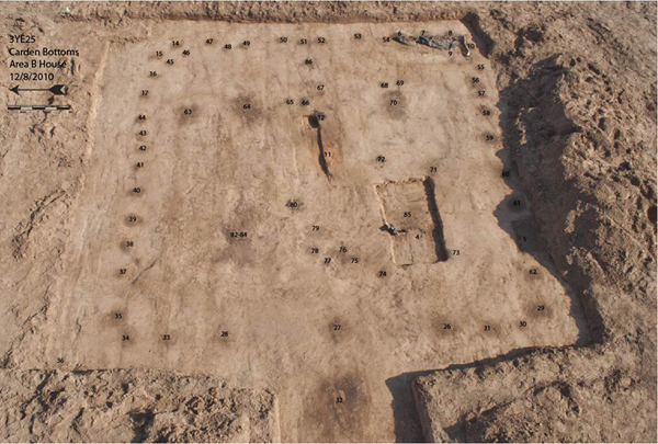
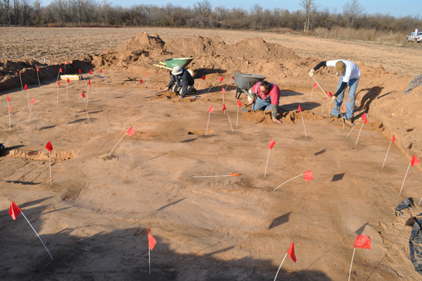
In the eastern United States, preservation of residential sites isn't great. The prevailing architectural paradigms favored wood over stone. When we looking for the archaeological remains of houses, we're scrapping off soil a few inches (or rarely feet) at a time, looking for patterns of slightly discolored soil that mark where the posts that framed the house. This, for example, is a well preserved archaeological residence from Arkansas; to give a better sense of scale, here is a picture of that feature being cleared.
If there are earthworks of one type or another, archaeological sites are easier to find. If we were to look at earthwork sites specifically, the map looks something like this one produced by Henry Shetrone in the 1930s. Shetrone's map includes earthwork sites that were known in his day regardless of their function. So not all of those depicted on the map are residential sites, and obviously, it's ignoring all the residential sites which don't include earthworks at all.
At the time of European contact, the largest settlement was probably one of those that didn't include any associated earthworks. In 1608, the Spanish-allied Timucua of northeastern Florida and southern Georgia requested that Fray Martin Prieto moderate a peace summit between them and the Apalachee to the west (based around modern-day Tallahassee). The summit was held at Ivitachuco, one of two Apalachee "capitals." Prieto reports that 70 Apalachee leaders attended the summit, representing 107 communities. He doesn't specify their titles, but I suspect these were the 40 or so holatas (mid-rank officials that oversaw territories beneath the nico, the principal leader of the Apalachee). The rest may have been inijas (officials that handled a lot of the day-to-day business for the holatas and kept the oral histories of their communities) or the leaders of individual towns and villages accompanying the holatas. Also in Ivitachuco were some 36,000 Apalachee according to Prieto. This roughly matches the 30,000 people described by Spanish traders who passed through the area briefly a few years earlier. Assuming these figures are accurate, Ivitachuco at the beginning of the 17th Century falls within the error bars of Cahokia at its peak in the 12th Century. The estimates for the whole Apalachee province generally hover around 60,000 but some go up to 100,000. Unfortunately we don't currently have the archaeological evidence to back up ethnohistorical evidence. As I said earlier, actually finding the remains of houses is difficult and we don't know the precise location of Ivitachuco, though we do know it was situated on the Aucilla River.
As for Anhaica, the other Apalachee capital, we do know more or less where that one was, and it's partially contained within the DeSoto Historic State park just east of downtown Tallahassee. Capafi, who was the nico at the time of de Soto's entrada, had Anhaica evacuated prior to the Spanish arriving. De Soto's men took up residence in the 250 houses that made up the elite central core of Anhaica and described many more houses spreading outward, a bit unevenly, for another three miles (some of these may have been parts of "suburbs" rather than part of Anhaica proper). By the 1630s, the Spanish had established a mission and fort (San Luis de Apalachee) outside Anhiaca, and the Apalachee built a council house there. While nothing from Anhaica and little of San Luis remains, you can visit a reconstruction of the council house if you'd like see what Apalachee architecture was like. Alternatively, this video will give you a quick look inside and out.
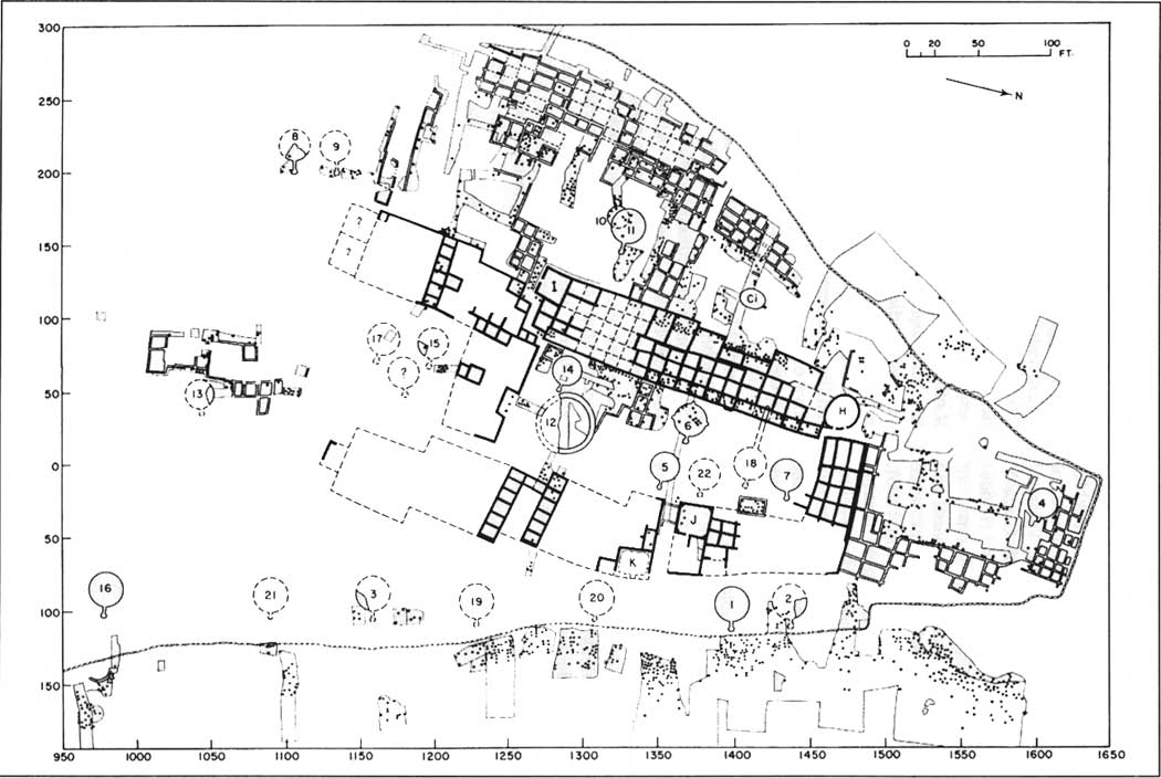
The population of the U.S. Southwest as a whole probably peaked around the 14th and 15th centuries, and this time period largely coincides with some of the largest pre-Colombian settlements in the region. As /u/Reedstilt already mentioned, several of the Jemez pueblos reached upwards of 1000 rooms in the 14th and 15th centuries. While a bit more modest, many of the other Rio Grande Pueblos reached between 500-1000 rooms. The Pueblos of the Cibola area (near modern day Zuni on the Arizona/New Mexico border) and in the Hopi region (in Arizona) also reached quite large sizes in this period. Several of the short-lived Pueblos further south along the Mogollon Rim on the Arizona/New Mexico border also reached fairly large sizes. By way of example, this is what the larger of two roomblocks at Pecos Pueblo in New Mexico looks like. This is a map of the Zuni Pueblo of Hawikuh, and an image of the site showing a lot of the architectural rubble. It is important to remember when looking at maps like these that most Pueblo settlements in this time period were multi-story, commonly 2 stories tall but often up to 3.
There are some fairly large settlements prior to the 14th century, especially at Chaco Canyon and in the Four Corners area. For instance, as already mentioned, Pueblo Bonito in Chaco Canyon (dating mostly to between A.D. 800-1150) has upwards of 300 ground floor rooms and rose to three stories in most places, and up to a full five stories in the very back. This is the tallest of any structure in the Southwest. There are a huge number of other "Great Houses" like Pueblo Bonito in Chaco Canyon, most of which are very well preserved.
That said, the degree to which these were actually residential structures is still a matter of debate. Early interpretation of the Chaco Great Houses was that they were largely empty ceremonial centers with a small, elite priestly caste living there. This interpretation has largely fallen by the wayside, and the debate is more over how much of a population lived in them. This is in contrast to the 13th and 14th century Pueblos I already mentioned, which are very much residential structures.
However, all this is somewhat misleading because archaeologists have long recognized that the 13th and 14th centuries in the U.S. Southwest are a period of aggregation where existing populations came together into fewer, but larger, settlements instead of the smaller and more dispersed settlements they had previously lived in. There was a population increase in this period, but part of the reason for the largest settlements dating to this time is also because of this aggregation of existing populations.
In part, our definition of a "settlement" or "city" doesn't wholly capture what population centers in the Southwest were always like. For instance, the Phoenix Basin (the location of modern-day Phoenix, Arizona) was likely the most highly populated area of the entire Southwest for much of the agricultural period (roughly A.D.200-contact), but even the largest settlements in the region never reached truly urban densities, even though the density of the region as a whole was quite high.
Here is a map of the very extensive canal systems coming off the Salt River in the Phoenix Basin. These miles and miles of canals supported a huge number of Hohokam settlements in the area, with each canal supporting tens of villages. Some of these villages reached very large sizes, such as Snaketown, La Ciudad, and Pueblo Grande, each probably reaching a peak population of 1000 or more after A.D.1100. Consider also that a similar density is present on the middle Gila River (also part of the Phoenix Basin) just to the south of the area shown on that map. You can see where the Salt River joins the Gila to the left-hand of the map.
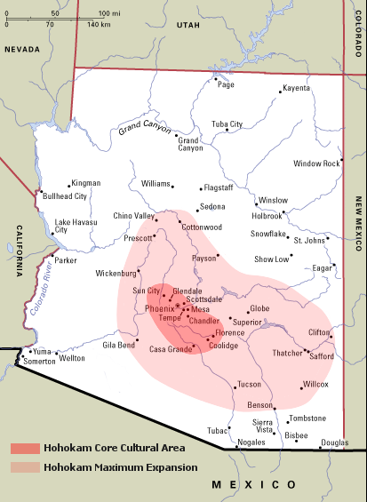
The population of the entire Phoenix Basin probably peaked at around 20,000 people in the early 14th century. That doesn't sound like much, but consider that the entire population of Arizona and New Mexico at the same time period is usually estimated at around 100,000! That is a really high density of people comparable to most of the rest of the Southwest, even though it didn't leave really extensive architectural remains (beyond those huge, sprawling canal systems). For reference, that means that about a fifth of the entire population of Arizona and New Mexico was living in the area shaded dark red on this map. This isn't a "settlement" in the traditional sense, but is a very significant and dense grouping of people on the larger landscape: think more suburban sprawl rather than inner-city New York or Babylon. Even that analogy is imperfect, because we can identify discrete villages within the Phoenix Basin (it isn't a continuous sprawl), but it comes closer to the reality than our ideas about cities and urbanism elsewhere in the world.