My name is Juandiego, i am mexican enthusiat of history and my current project is to create the map of the continent back on 1490, i have the basics on mesoamerica-andes cultures but i am totally lost on all the upper north american area (aka Canada and the US), also brazil and most of the caribean. Here is ye link of this map: http://purahistoria.com/mapa_en.html There is a place to comment on the website but you can do so on this trend. I know that this is hard because there are no maps of this age and a lot of the tribes where nomads and stuff, but lets hope for the best. Thanks in advanced :)
Unfortunately, this post is going to have a lot more "Why available maps are wrong" than actually providing specific answers. Piecing together the information you want is going to take a lot longer.
There are a few maps out there representing "pre-colonial" North America. Most will look something like this. Most are ultimately based on Sturtevant's map that was made for the Smithsonian's Handbook of North American Indians, and they've inherited the same problems as the original.
The biggest problem is that these map do not represent any particular time. They're generically "pre-colonial." They basically represent who was living in a particular area when Europeans / Euroamericans arrived there.
This results in many anachronisms. For example, both maps show the Erie living east of Lake Erie and the Comanche living in Texas. But the Erie and the Comanche were not contemporaries. The Erie were defeated by the Haudenosaunee (the Iroquois Confederacy) in the mid-1600s and were absorbed into the confederacy as prisoners of war or into other nations as refugees. The origins of the Comanche as a distinct people begins in the late 1600s, when a Western Shoshone band split off from the others over a disagreement on whether to fight the Cheyenne. Those who opposed the war headed south out of Wyoming and became the Comanche. In the early 1700s they were still a historical footnote, allying themselves with the more powerful Utes to threaten the Spanish. It would be quite a while until they became the major power in the Southwest as represented on the map.
Another problem you'll have with these maps is that since they show the situation as it was when Europeans reach an area, that can be centuries removed from 1490. For example, the Lakota (labeled as the Teton on both maps) are shown in their 19th Century territory. Turning the clock back to 1490, they and the Dakota (Yakton, Yaktonai, and Santee on these maps) would all be living in the upper Mississippi valley. So would the Cheyenne. In fact, most of the northern Plains would need to be shifted eastward considerably to represent the situation in 1490. In the central and southern Plains, the situation is even more complicated.
The third probably is that since these maps represent the historical situation, they largely ignore the protohistoric nations which would be the ones you would be most interested in. This is most noticeable in the Ohio Valley, which is pretty much blank. There were, of course, many people living in the area in 1490, but the area seems to have been hit by an epidemic of some sort around 1635 and then invaded by the Haudenosaunee during the Beaver Wars throughout the latter half of the 17th Century. The nations that were there at the time were either absorbed into other nations like the Erie, or forced out of the area - this is the start of the domino effect that eventually pushes all those previously mentioned nations onto the northern Plains, for example. Not everyone went west. The Quapaw and the Ofo went south. The Shawnee eventually held their ground in Kentucky for a while until defeated by the Chickasaw-Cherokee alliance in 1717, then eventually allying with the Haudenosaunee and reclaiming Ohio. Plus the Ohio Valley would also have societies that are known today only through archaeology (with perhaps some scant historical mentions and possibly links to known peoples who had been displaced from region) - notable examples, from upriver to downriver, include the Monongahela, the Fort Ancient, and the Caborn-Welborn cultures.
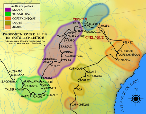
Florida, as depicted on those maps, is pretty much as accurate as we can get for the 1500s. The most famous Native Floridians - the Seminoles - wouldn't arrive in the area until well after European contact. The rest of the Southeast would look quite a bit different. Instead of the Catawba, you'd have Cofitachequi. Instead of the Cherokee and the Muskogee / Creeks, you'd have Coosa (on the Smithsonian map you'll notice Coosa is included within the Muskogee area - this is a later town established by the citizens of Coosa after they helped found the Creek Confederacy once the Coosa Chiefdom declined). This map will give you an idea of what the situation looked circa 1540, showing the various late Mississippian nations that de Soto encountered at that time. Archaeologically, these would have been around decades earlier with 1490 so you're probably fine using that map as a source. You'll also notice "Chicaza" on this map. That's the Chickasaw. At this point they're still a fairly small nation and, again, further east than they are on the other maps. Here's the companion map for lower Mississippi at the same time. On this map, you'll see Quigualtam, a Natchezean nation; the polities to the north of Quigualtam are mostly Tunica. You'll notice on the historic maps that the Natchez and the Tunica are both much further south. In 1490, Natchezean peoples probably populated the Lower Mississippi, from where Quigualtam was to where the Natchez are on the historic maps - archaeologically it doesn't look like the Natchez moved into area as part of post-colonial territorial disruption, but rather contracted into the southernmost portion of their territory.