Is "kingdom" an accurate word to describe the government structure of these areas? Were they unified central governments like the Tarascan empire?
It seems to gloss over Maya territories, but it's the areas west of the Aztecs that I'm interested in.
The borders also seem to coincide with this other map (Warning: it's an .svg file that's WAY bigger than it needs to be -- you'll have to zoom in). I couldn't find an information source for either.
I'm going to focus on Xalisco and Tonallan (or Tonala) since I know the most about them. Colima and the Postclassic/Contact period Colima is something I am unfamiliar with. I also want to preface this by saying that within the modern state of Jalisco and Nayarit, the pre-Columbian period is poorly understood compared to other parts of Mexico. What we know is quite scant and the information is going to feel lackluster. There's not much we can do about it without incentivizing the area for research and providing funding for said research.
The map is kind of accurate in that the cities/towns of Tonala and Xalisco existed and were in the general region of that map. I would hesitate to say they controlled such a large and vast region, though. As far as colonial accounts go, the region was quite fragmented with many different cultural and linguistic groups in an ever changing web of alliances and feuds. Some may have controlled a chunk of territory with a network of towns, but it would not be as large as the map is making it out to be. This is what made the region so hard to control and what aided in Natives being able to coordinate with one another and rise in rebellion in the 1540s. With the Spanish unwilling or unable to recognize and document so much diversity, messengers could openly walk between cities and towns relaying information. What made the Mixton Rebellion so successful at first was its surprise in which numerous towns rose up in one night expelling the Spanish and their Native allies in the region.
As for what Tonala and Xajlisco looked like or what we know, the information is a little spotty. I'm going to start with Tonala. Tonala was a ceremonial center located in southeastern Guadalajara is. Despite its large size and relatively well preserved ruins compared to other sites in the Guadalajara area (Ixtepete and El Grillo), the site of Tonala was illegally bulldozed by the city of Guadalajara to create a municipal dump. All we have left to us is a rough sketch made by Phil Weigand (1996). I have never come across any photos of the site and I don't know if any actually exist. Apparently the dump has been shut down and is in the process of being relocated because Guadalajara has grown so much and people don’t like the smell. Hopefully someone can go into that dump after its been cleaned and do some proper work, even if it is just test pits to look for foundations and whatnot.
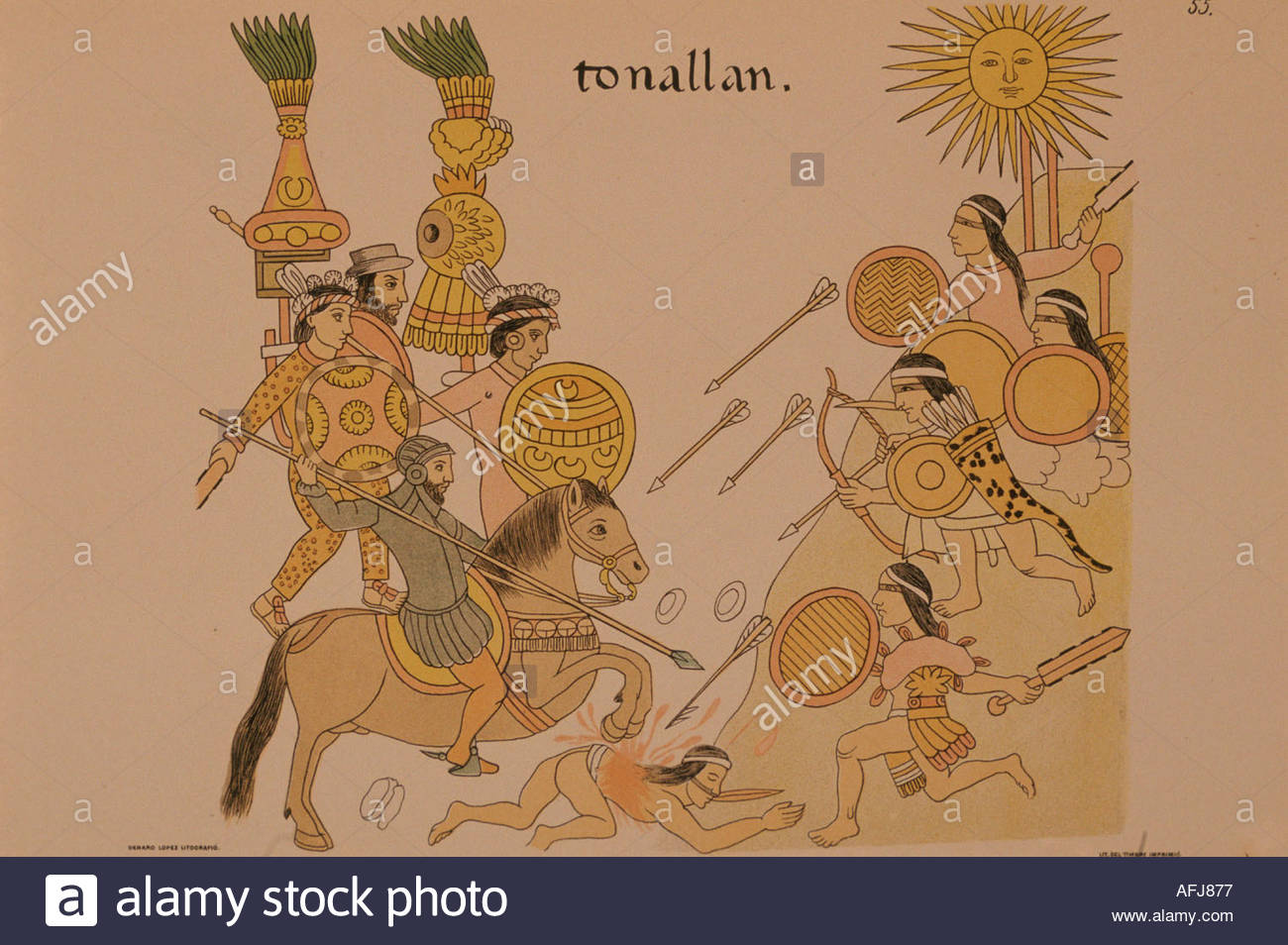
Despite the lack of archaeological documentation for the site of Tonala, Tonala itself played an important role in early colonial history. According to Ida Altman and her book, "The War for Mexico's West", Tonala was a Texcuexe community lead by a woman cacica (2010:37-38). Arceo, Guzman's record keeper in his 1529-1531 expedition to Jalisco, says that Tonala consisted of "six thousand houses located on a fertile plain with abundant crops and fruit trees". One of the cacica's daughters, with the aid of other allied towns, lead an attack against Guzman but was defeated. In the Lienzo de Tlaxcala there is a picture depicting Guzman and his Tlaxcallan allies fighting against the Tonallan troops.
When Guzman returned from his expedition in 1531 to the Tepic/Tonala area (so says Altman, but Tepic is in Nayarit so this is confusing), he had found that his position as governor of New Galicia had been revoked and in his place was Cristóbal de Oñate. Guzman captured Oñate and sent him back to Mexico City in his declaration that New Galicia was semi-autonomous with Guzman as its leader (Altman 2010: 54-55). In 1531 Guzman founded several towns, one of them being Guadalajara named after his home town in Spain. Guadalajara had several locations before its final placement in the Atemajac Valley today. First it was located at Nochistlan, then Tonala, then Tlacotlan. After the Mixton War its permanent position was settled where the city is today (Altman 2010: 60)
Guzman and the other Spaniards were not kind to the people in New Galicia. A Spaniard named Juan Bautista testified that he encountered people from Tonala as far as Colima carrying loads of goods for their Spanish lords. Apparently it was quite uncommon for Spaniards to send the Natives of their encomiendas on such far journeys. Francisco Vasquez in 1538 noted that he encountered people just west of Mexico City carrying loads back to New Galicia that were starving from hunger since their loads did not provide for them any food for their journey (Altman 2010: 80-81). But this is side information and not super pertinent.
As for Xalisco, despite its name, it was not actually located within the modern political boundaries of the state of Jalisco. Xalisco was in fact near the modern city of Tepic in the state of Nayarit, Jalisco’s neighbor to the west. During Francisco Corte’s expedition in the 1520s he reported that Xalisco was made up of 400 houses and 800 men. The lords told him that they had no marketplace and conducted no trade and lacked subject communities. When Cortes did meet with the lords of Xalisco he was apparently greeted with seven jars of gold. Alonso Quintero makes an unclear note about Xalisco. It seems that the town may have allied itself with Cortes in exchange for aid in conquering nearby towns and capturing people (Altman 2010: 12-13). Unfortunately I am not aware of any drawings of the town or any more detailed descriptions.
During Guzman’s expedition ten years later, he had sent some of his captains to scout the Tepic/Xalisco area. They reported that both were large towns in close proximity to one another, but occupied by different ethnic groups. They also had recently finished a war between the two. One of the captains sent messengers from Tepic to Xalisco to summon the lords in order to talk to them, but because Xalisco and Tepic were enemies the lords of Xalisco refused the summons and killed one of the messengers. This forced Guzman to go to Xalisco itself. There the lords tried to offer Guzman and his people food and Guzman tried extracting tribute from them instead. This didn’t please Guzman and he decided to wage a war on the town. He ordered a war of “fire and blood” and ordered that the people of Xalisco be made slaves. In his war he burned the town and pursued people into the mountains to enslave them. With two of the Xalisco captives, Guzman cut the hands and nose off of one and tied the hands to the captive’s hair. With the other captive he cut his hands off, as well, and hung the man from a tree. He proclaimed that those that do not submit would meet a similar fate (Altman 2010: 42-43). In the same Lienzo de Tlaxcala there is an image (top one) of the Battle of Xalisco between Guzman’s forces and the warriors of Xalisco.
There is an account written by Altman about the tribute demands placed on the people of Xalisco, but I’m not sure if you are interested in that or not. If you are, I can type out what she says.
Here is a map of Nueva Galicia in 1550 to give you an idea where some of these other towns are located.
http://i.imgur.com/ElZC3DS.jpg
I also have these topics on Postclassic/contact Jalisco if you are interested.
References
Altman, Ida. The War for Mexico's West: Indians and Spaniards in New Galicia, 1524-1550. University of New Mexico Press, 2010.
Weigand, Phil C., and Celia García de Weigand. Tenamaxtli y Guaxicar: las raíces profundas de la rebelión de Nueva Galicia. El Colegio de Michoacán AC, 1996.