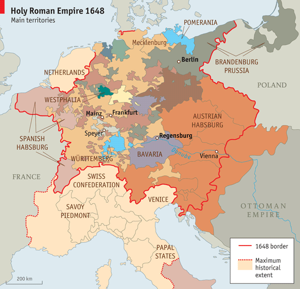
The Holy Roman Empire was (obviously) a very complicated entity. Modern maps often will try to show some range of this complexity, ranging from showing the major members and labelling the rest "SMALL STATES" (such as with this map) or trying to show as many of the member states as possible (such as here). Modern maps show independent political entities, and it's generally accepted that the member states of the Empire (especially after the Peace of Westphalia) were more or less independent.
However, maps made when the HRE still existed often only show the borders of the HRE, often labelled "GERMANY" or "THE EMPIRE". While individual areas may get their own smaller labels, no attempt is made to show internal borders (frex this map from 1650, or this map from 1598).
Is this because cartographers of the time couldn't be bothered to map out each and every minor fiefdom? Or, was the understanding of "sovereign state" different in the 17th century than it is today?
It is definitely true that our ideas of 'sovereignty' and 'states' has changed significantly since the end of the Thirty Years War. Indeed, one of the classic 'starting points' for study of modern international relations is 1648, and the Peace of Westphalia, with the eponymous 'Westphalian State' serving as the standard description of what we in the modern world would consider a state.
Now, I am no expert in the history of cartography, and so can't go into as much detail on the evolution and development of cartographical standards. Most of my focus is on the military and political history of the Austrian Habsburgs, and their role within the Imperial system. However, I will note that of the maps you linked, both of the modern ones are dedicated maps of the HRE, and will of course focus on highlighting some of the more important and prominent actors within the HRE. Of the historical maps you linked, one does just label the whole of the HRE as 'Germany', but the other does have labels for the individual regions.
That aside, I'll focus a bit more on your question regarding the sovereign state issue. By the early 17th century, there was definitely a clear feeling of a 'German' identity and 'German' liberties. While the princes of the Empire might well heavily disagree with the policy of an individual Emperor, there was still a great deal of respect for the position of Emperor. Moreover, in contrast with the popular conception of the HRE as 'neither Holy, Roman, nor an Empire', the HRE did have internal governing mechanics and structures for governance of the Empire as a whole. Moreover, while there were strong efforts at centralisation later on in Europe, maps tend to distort that by diving into the various constituent polities of the HRE, but not doing the same for the same polities of other European states, instead leaving them as single colours, creating the impression that polities like 'France' and 'England' were unified in contrast to the disunited HRE.
But to get the core of your question, there's not really the same sense of the 'sovereign' state in the early modern that we have in the modern world. As mentioned, one of the core concepts of modern international relations is the idea of Westphalian sovereignty, i.e. that the primary actor in the international sphere is the state, which holds power to the exclusion of others within its borders, but also has no power over the domestic actions of others. Moreover, all states, regardless of power, are supposed to be 'equal' in the face of international law. It doesn't matter if you're Andorra or Germany, if you're a sovereign state, you--as a state--have the same right to sovereignty within your borders, and other state should respect that right.
It's common to say that this system came about as a direct result of the Peace of Westphalia at the end of the Thirty Years War, which helped to establish the idea that each 'state' had a right to sovereignty within its borders. While we can to go on to criticise the idea of Westphalian sovereignty, the extent to which it's a thing, etc. it's still a key point of modern thinking of international relations, and it's not that far a jump for this kind of thinking to manifest itself in creating maps of the period. At the same time, for more historical maps, when the HRE had a great deal of internal structure, it is also fair for it to be depicted as something akin to one of the other polities of the period.
I hope this has been helpful in answering your question, and please feel free to ask any follow ups.