Some examples:
https://en.wikipedia.org/wiki/Hittites#/media/File:AlterOrient2.png
http://www.historyofmacedonia.org/AncientMacedonia/images/macedonianempirelarge.jpg
http://www.standstillawhile.net/wp-content/uploads/2011/05/Seleucid_Empire.gif
https://en.wikipedia.org/wiki/Sultanate_of_Rum#/media/File:Anatolian_Seljuk_Sultanate.JPG
The Pontic Alps probably have a little something to do with that.
I'm no scholar of the ancient empires OP mentioned, unfortunately. However, during the later Middle Ages, the southern Black Sea coast (northern Anatolia) and the Crimean peninsula hosted a number of Byzantine splinter states and Italian trading colonies even while Byzantium, the Seljuk Turks, some Mongol interludes, and finally the Ottomans took most of Anatolia itself. The Empire of Trebizond is probably the most famous of these kingdoms, and was the most enduring.
There's no question that Trebizond and its partners benefited massively from geography and climate. The mountains had (have, I think) one major pass, so controlling that seriously limits land-based aggression. And apparently the highlands beyond it are not the best for supporting an incoming army:
In 1292 Edward I of England's embassy to the [Ilkhanate] found themselves hard put to lay hands on much to eat beyond the Pontic Alps: no wine, no oil, no fruit, no green stuff, some animal grease and a little meat. (Anthony Bryer)
Furthermore, the coastal regions themselves are sharply distinct from highland Anatolia--forested, dark, wet. The Oghuz Turks' oral epic Book of Dede Korkut, which probably dates from 1400 or so, acutely warns against descent from the Pontics towards the Black Sea climate zone:
Son, in the place where you would go,
Twisted and tortuous will the roads be;
Swamps there will be, where the horsemen will sink and never emerge;
Forests there will be, where the red serpent can find no path;
Fortresses there will be, that rub shoulders with the sky....
Your destination is a frightful place. Turn back!
Additionally, it's important to remember when looking at maps of old empires that the giant colorblocking is more of a suggestion than a geopolitical reality at any given moment. They don't depict sovereign political/legal rule according to international law like modern country borders do. So just because the Seljuk blue runs up to the southern fringes of the Pontics, does not mean the Seljuk army was massed and pointed north. It would have been sparsely populated pastoral villages.
We are of course many decades past Braudel and geographic determinism, so we mustn't leave it as simple as "there were mountains in the way." After all, Trebizond didn't last forever! (It didn't even outlast the Middle Ages; the Ottomans conquered it shortly after taking Constantinople.)
Anthony Bryer wrote a really interesting article, although it's pretty old at this point (1975), arguing that the relative compartmentalization of Trebizond and its Pontos companions contributed to a stronger sense of local identity which enabled greater resistance against invaders. In particular, Bryer focuses on organized rural enclaves ("banda") as a source for organization and defense by locals on one hand, and a reason that the region was less appealing than it might otherwise have been to invaders on the other: there wasn't a glittering "golden apple" (Reichsapfel, the imperial orb) and the riches it represented to conquer like the Ottomans poising themselves at Vienna.
Hopefully someone with knowledge of the ancient world can talk about those particular situations. But in the later Middle Ages, it was definitely a case of how humans interacted with the geography of highland plateau, mountains, and a dense forested coastal zone.
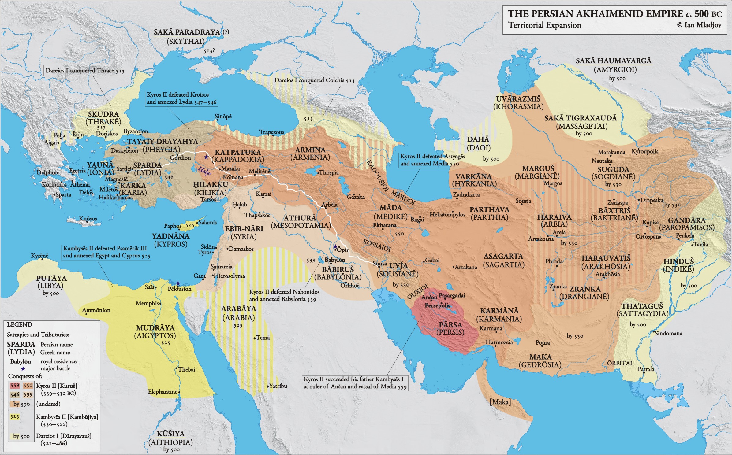
The pattern you're seeing is the result of cherry picking. Here's maps showing Pontus and Cappadocia as part of the Achaemenid Persian Empire, the Roman Empire and the ensuing Byzantine Empire, and the Ottoman Empire. In other words, for most of recorded history, the Black Sea coast of Asia Minor was under the sway of the nearest major imperial power. It remains a part of the modern Turkish state.
The reason why the area managed to retain its independence in the periods of the empires you mention is usually that it was united in a strong imperial state of its own. While I can't speak with confidence about the Late Bronze Age, the situation at the time of the Macedonian and Seleukid Empires didn't present any obvious opportunity for nearby powers to absorb the state based in the area. In the later 4th century BC, the Persian satrapy of Cappadocia rebelled against the Great King and acted as an ally to Macedon, and in the ensuing decades the Mithradatic dynasty built up a Pontic Empire that would eventually come to include most of Asia Minor and the Black Sea coast right up to the Crimea. Far from being a target for nearby empires, the kings of Pontos actually expanded into Seleukid and Ptolemaic lands, and repeatedly came to blows with Rome. The entire domain was eventually conquered by Rome and incorporated into their new provincial system.
After some 1300 years of only occasionally contested Roman domination, the region broke away from the Byzantine Empire in the 13th century AD to form the Empire of Trebizond. Again, the reason why it wasn't incorporated easily into the Seljuk Sultanate was the simple fact that a strong state already existed in the area, and wouldn't be overrun lightly. Only the new power of the Ottomans was able to take Trebizond - but only after they took Constantinople itself.