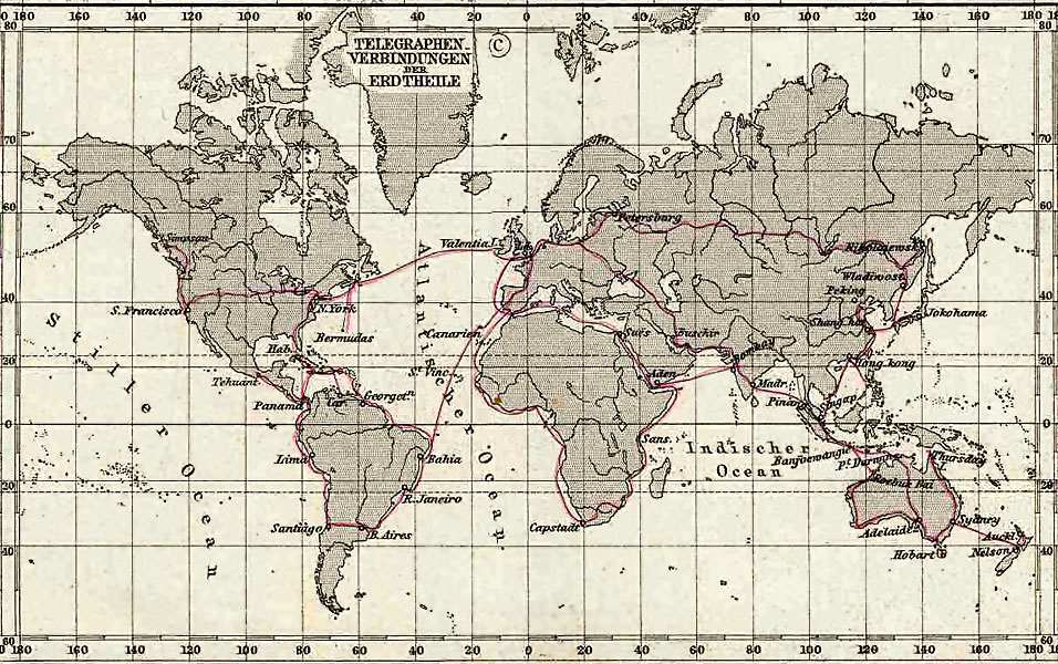
This map indicates that there is a telegraph line running down to Bermuda in 1891. When thinking of the various British overseas colonies at the time, Bermuda doesn't rank very high. Why was this built?
First of all, that's an incredibly interesting map for a number of reasons. Thanks for sharing, and do you happen to know why they cut across S. America rather than rounding the bottom of Argentina? From what I know of the land terrain there it's not exactly easy going.
As for your question, a likely cause for the telegraph line was the Royal Navy Dockyard in Bermuda, and the island was also the headquarters for what is we call the North America and West Indies station (which had existed in some form or another since the 1750s fighting the French). The central location used to bounce between Halifax (which is where it looks like the telegraph line hits NA on the map) and Bermuda, but by the time the map and telegraph lines were created, it was mainly based out of Bermuda, which was one of the UK's main military bases in North America and their "protection" against US military action. As such, telegraph lines would have been a decent priority for the island, especially given the British were clearly willing to drag the line across continental US and Argentina/Chile for the sake of connectivity.
Edit: If you also look at a map of British holdings (this one is from 1897), there's not a ton in the upper Caribbean, other than the Bahamas, which was much less exciting for the British. Your telegraph map also shows all of the British holdings connected, so the Bermuda connection could also just be a result of the empire giving all territories telegraph access, and it was easier to run a separate direct line from Halifax (where the military operation still had an operation) to Bermuda through the ocean than tack on a connection from the rest of the British Caribbean.
Link for British map: http://www.britishempire.co.uk/images4/worldmap1897large.jpg