Follow up question, what did "Mexico" actually mean as a term to mesoamericans? Was it just a synonym for Tenochtitlan and Tlatelolco? Did it refer to all of the Valley of Mexico? All of the Central Mesoamerican plateau? The entire known landmass?
How does that intersect/compare with '"Anahuac" and "Cemanahuac" as terms?
I'm a bit late to this, but can give some insight for the Spanish American context. First off, when talking about pre-colonial "America" we have to keep in mind that while there was exchange between different population groups over large distances - there would not have existed a knowledge of the whole South American or North American continent, or even of the Americas. So a more useful way of framing the question could be to ask how native people called their own states, or (often on a more cosmological level) the known world.
I'll have a look first at terms used by the pre-colonial/colonial Nahua (aka Aztecs) of central Mexico, and then more briefly at the South American Incas. These were the two largest states at the time of conquest in Latin America, so we have quite some knowledge of their perceptions.
Anáhuac/ Cemanahuac
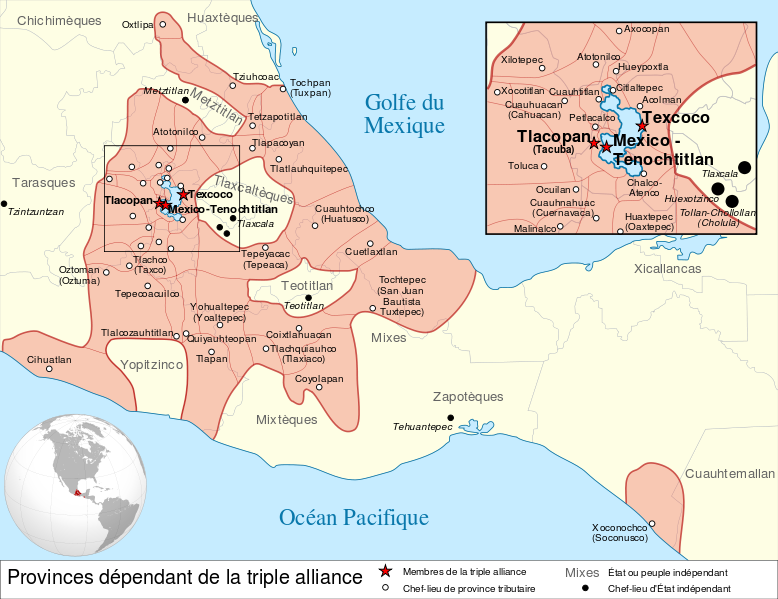
The Nahuatl term Anáhuac means "beside/close to water" and is most commonly used for the Valley of Mexico in central Mexico. More specifically it would have designated the south-central part of the valley, and was sometimes even used for Mexico-Tenochtitlan and its surroundings. The Nahua and the Triple Alliance (the dominant political entity in the Valley of Mexico just before European contact in 1519) did not have an exact European border concept, which might add to why different interpretations exist for the space of Anáhuac (this map gives an idea of the Triple Alliance's extension before conquest). John Bierhorst in his Nahuatl-English dictionary gives us the following meanings:
- At the seashore ..., close to water ...
- At the shores of paradise...
- New Spain [following Motolinía's memoriales], the known world before Cortés...
So while 1. can fit with the Valley of Mexico (and/or Tenochtitlan, being close to Lake Tezcoco), with 2. we have a more spiritual meaning, and with 3. even a meaning extentending over the whole of colonial Mexico. This last one was very probably strongly shaped by colonial views, as the author draws on the Franciscan priest Motolinía here. Overall, the most common use for Anáhuac is for the Valley of Mexico though.
To make matters slightly more complicated, there was also the term cemanahuac (which I haven't come across as much). It comes from the words "cē" meaning one/whole, and "Ānāhuac" as described above. It can be translated as "land completely surrounded by water". The most probable definition of this would be the land mass known to the Nahua, surrounded as it was by the Pacific and Atlantic oceans. According to Bierhorst
- The world, the earth... [drawing on Motolinía again here], the whole world, in the world, throughout the world, throughout Anahua (the known world before Cortés); the Aztec empire (?...)...
- The eternal shore, paradise
- Island, the city of Mexico (?, usage expressly forbidden by Motolinía...)
Again we don't have one fixed meaning here. I'd still note that Cemanahuac would have designated a larger unit that Anáhuac - referring most probably to the lands (or world) known to the Nahua. Not also how we have again a spiritural meaning under 2. here - although the meaning of "paradise" should to be taken with a grain of salt. While Franciscans like Motoliía drew on Christian terms, the Nahua notions of an afterlife were very different from the Christian paradise.
Tawantinsuyu
This term was used by the Incas for their empire, probably the largest in the pre-Hispanic Americas. In its official language Quechua it comes from “tawa” meaning four and “suyo” meaning state. It is often taken to mean "the Four Regions", referred to the Inca empire's division into Chinchaysuyu, Cuntisuyu, Qollasuyu, Antisuyu, terms which partly continue in use today (this map gives an idea of the four regions ). While these regions were loosely tied to the cardinal directions, their center was at the imperial capital city Cuzco; apparently once again the limits of the regions were not clearly fixed. By the 1530s the Incas had formed a large state with its center on the Andes. At the point of its largest extension, the Inca state consisted of modern-day Peru, large parts of modern-day Ecuador,parts of modern-day Bolivia, north and central Chile and northwest Argentina.
To this can be added the pacha concept. It was used to divide the different spheres of the cosmos, on three levels. The levels or realms were not only spatial, but simultaneously spatial and temporal, differing strongly from European spatial conceptions. In a maybe similiar way, Mesoamerican cosmology also knew a conjoining of spatial with temporal notions.
I'm less familiar with the Incas than with the Nahua, so hopefully someone can add to this very brief overview. Hopefully it's shown that there were different conceptions of the pre-hispanic known world in different parts of Latin America - the two just mentioned being only the best-known examples. And that there was often a conceptual division between the known world and a cosmological view of the world.
Lastly, I also wanted to mention that the term America did come up following Amerigo Vespucci's expeditions in Nothern America, especially after its usage in the Waldseemüller map of 1507. However, especially in the Spanish empire the earlier term "the Indies" (las Indias) continued in usage during colonial times - the misnomer of course being connected to Columbus' first claiming to have found the western route to India/Asia. In order to distinguish these Indias from the Asian ones, the terms Indias Occidentales (America) and Indias Orientales (Asia) were introduced.
Edit: Added maps and some context
Did they have a name for it? Or did they just call it "home" or something synonymous?
What did any one tribe know about the shape and size of the landmass on which they dwelled? Did they ever send out the equivalent of explorers or cartographers? Did they make maps?
So many more questions as I have never studied this topic in depth! I'll end it there I suppose. Hope these are allowable.