Some background
I am currently enrolled in a teacher credentialing program in California. I am training to become a secondary school History teacher and today in one of my classes I heard a claim that intrigued me.
One of the candidates in my program told an anecdote in which they had informed a student they were working with that Columbus had received a map from the Moors via his brother Bartholomew, which showed him how to get to the Americas.
My initial reaction to this claim was extreme skepticism as I have heard a lot of dubious claims about he Moors having discovered the Americas at an early date previously. In the past I have even heard claims that the pre-columbian civilizations such as the Olmecs were in fact founded by settlers from West Africa.
When I see these types of assertions on Youtube or Facebook it is generally a curiosity for me what their origin is or what type of evidence they use to support such a claim.
However, when I researched this anecdote I literally could not find a single reference to any such claim on the internet.
Does anyone know of any conceivable evidence for such a claim? Even if this evidence has been radically misinterpreted or confused? I have heard of Columbus using Moorish maps to calculate the circumference of the globe, could that be what this person is referring to?
Okay, given the lack of information provided, it's hard to make a counter-argument as there is basically no coherent argument to counter.
But, let's try to upack it
Columbus had received a map from the Moors via his brother Bartholomew, which showed him how to get to the Americas.
I am not aware of any record of Bartholomew indicating he received some sort of map from the Moors. While I can't say I have read every single record to be able to say it 100000% didn't happen; without citations of where it could be found I can't do much. And the burden of providing proof is anyway on the proposer of the theory.
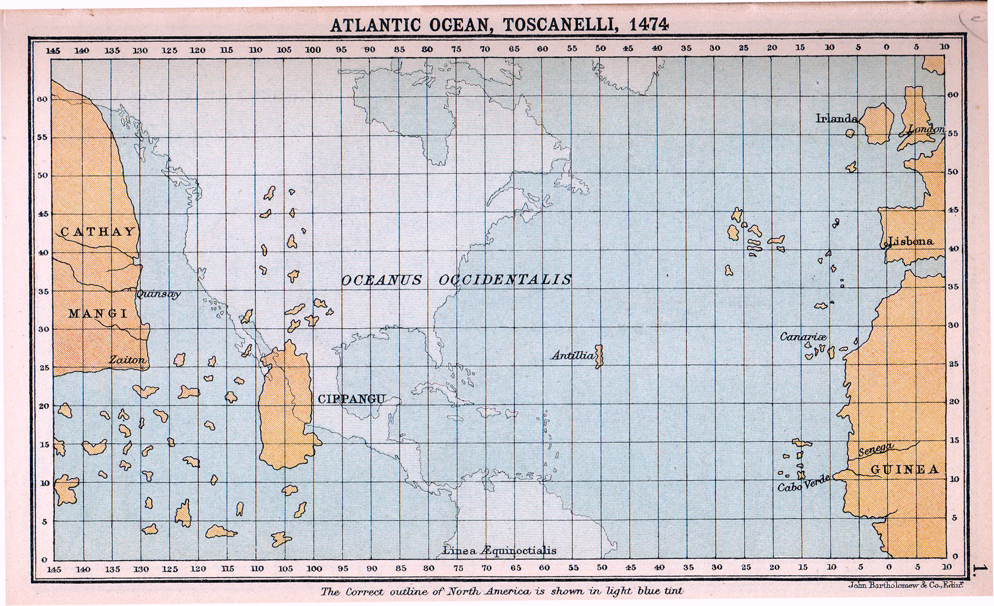
The Columbus brothers were navigators and cartographers and could probably had all sorts of available maps pass through their hands, but the number of maps available wouldn't be that large and diverse. We do know that Columbus had access to, and placed great trust in the (modified) map of Toscanelli, an italian cartographer, as we can see from plenty of records in Columbus letters where we find a copy of the Toscanelli letter and from his log of first voyage where he frequently mentions the non-existing islands of Antilles, Cipangu and in general near land of Cathay. Given that all that information is incorrect, it would be really strange that the supposed Moorish map to America would feature the same made up places.
I am also not sure how would a map showing "way to America" look like. Atlantic ocean wasn't some sort of maze you had to map your way through. It was an open ocean, where routes were dictated by wind and current patterns. And those kind of information don't appear on any of the maps of the period, but were known by experience. Columbus basically didn't do anything that needed some special maps. He dropped south to latitudes of Canaries, which was regularly done at that point, and sailed straight west following the trade winds. I really don't see what information any map could provide him in this regard. And again, we see from his logs that once he arrived in Caribbean, he had no idea where he was and what the places looked like and he was completely clueless and expecting stuff to be as in Toscanelli map. Any idea that Columbus had any sort of map which would provide correct geographical information can be dropped given his own records in his log.
Now little about the mysterious Moorish maps. Usually when islamic maps are mentioned in connection to America, one of two is usually meant.
First is the 10th century map from Andalusian moorish historian and geographer Al-Masudi. In his work Meadows of Gold he mentions briefly an adventurer who sailed out of Straits of Gibraltar to an unknown land and returned with riches. There is also provided a map of the world, as shown here.
Both of the references, the story and the map, created considerable attraction in Pre-Columbus contact theories. However both are really unsubstantiated. The map for example shows a landmass south of Africa, detached from it, causing some to claim it shows South America. However, the position of the landmass is way off, and most likely shows the southern imagined part of Africa. The seperation of Africa in two landmass was actually a relatively common theory that Southern and Northern Hemisphere are separated by an impassable ocean, and this map was one reflection of it. Here is another map, by Macrobious a showing similar thing.
The story also isn't any indication of anything. The fact that someone sailed out of straits of Gibraltar and reached an unknown land doesn't mean that person reached America (let alone proves it). Why is it assumed he went west? He could have went south or north, which is far more likely given that the wind patterns at those latitudes would prevent one from going west. If he wanted to go west he would probably have to do as Columbus and go down to Canaries latitudes. By that point he would already be going considerable way south, so why would he change course, and ultimately find Canaries, also an unknown land where he could have made riches. Going further South he could reach West African lands, also a source of gold. If the event even took place, it is a far more likely option.
The other map usually meant, is the Piri Reis map of 1513, but this map can't be relevant, as it post-dates Columbus, and the author (Piri Reis) himself admits in his notes he used various maps captured from the Spanish and Portuguese, even some from Columbus himself, to draw the maps. So, this maps can't be used by Columbus as they were copied from Columbus.
In any case, I would reiterate that we don't have any records of Columbus nor his brother, becoming familiar with any of this maps.
In the past I have even heard claims that the pre-columbian civilizations such as the Olmecs were in fact founded by settlers from West Africa.
For more reading check out /u/CommodoreCoCo post on debunking this very theory or /u/400-rabbits post in general on theories of Islamic knowledge on Americas
I have heard of Columbus using Moorish maps to calculate the circumference of the globe, could that be what this person is referring to?
Columbus did form his idea on the circumference of the globe by adopting a value from Arabic geographer Alfraganus while making a mistake of not transforming the values from Arabic miles into Italian miles. However, Columbus had no direct access to Alfraganus work, but had taken his numbers (and the mistake) from Pierre D'Ailly's work Imago Mundi who probably also didn't directly read Alfraganus but took it in turn from other authors like Roger Bacon. It was a convoluted complex process, which I tried writing on here and here