The Mauryan Empire reached its peak under Ashoka, who ruled for 37 years till his death in 232 BC. After him the empire would break up. The Ganges Plains would remain under the Mauryas, and form the nucleus of the kingdom of their successors. The north-western areas (largely modern day Afghanistan and Pakistan) were lost to the Bactrian Greeks. Rajasthan (and Punjab) saw the re-emergence of gana-sanghas - a rather unique form of republics (or what some would call proto-states) that were quite prominent across Northern India prior to the arrival of the Mauryas. Other states that had been conquered by the Mauryas similarly broke away and resumed being their own kingdoms like Kalinga and the states of the Western Deccan.
The formation and break-up of the Mauryan empire was no mere coincidence, but strictly followed the limitations of the geographic confines of the subcontinent. The Mauryas were the first empire to rise from the Gangetic Plain, which itself was mostly thickly forested till the arrival of the Iron Age migrants including both the descendants of the Indus Valley cultures and the Vedic people. As the forests were cleared and people settled there, the first states and cities in the Gangetic Plain started to form in the 6th century BC. Now its easy to see how one state could rise up and conquer all the other states in the plain, as the Nandas would do by around the time Alexander fought Porus in 326 BC . Such a state could from time to time become more powerful than all other states on the sub-continent, and go on to conquer others, as Chandragupta Maurya would do after he took the Nanda throne in 321 BC. However there were strong disincentives to such growth.
If we re-examine the Mauryan breakup:
Rajasthan would revert to a multi-state situation, which it would remain in for most of its history (Rajput kindgoms would replace the jana-sanghas, and accept the overlordship of Gangetic power only sporadically and grudgingly)
The states in the Deccan (South) would similarly be independent of the Gangetic power except for brief periods
The North-Western parts and Punjab would practically act as a "Gateway to India". Strong Gangetic powers would hold these regions. When they couldn't these regions would be independent till a Western power conquered them, and then invariably took over the Gangetic Plains as well. And this was the key. A Gangetic power had to hold on to Punjab and the Northwest. They were separated from the South by the still thickly forested regions of Central India, the Vindhya mountain range and the Narmada river. Hence an expedition to the South was always an expensive proposition and presented the risk of exposing the Northwestern front. In fact two of the biggest territorial empires post-Ashoka were those of Sultan Mohammed Bin Tughlaq and the Mughal Aurangzeb. Both spent time expanding in the South, with immediate backlashes. Mohammed Bin Tughlaq would face Mongol invasions from the Northwest, and the rise of the powerful Bahamani empire in the South. But at least the Sultanate survived. Aurangzeb's 25 year campaign in South India was at the cost of ignoring the Northwestern frontier which would directly contribute to the rise of Nadir Shah, who would conquer Delhi and make the Mughal a vassal just 30 years after his death. But more importantly it would unleash a new power from the South - the Marathas - who would contribute to the breakup of the empire just 10 years after Aurangzeb's death. On the other hand Sultan Allauddin Khilji would merely send an expedition to extract tribute from the southern kingdoms.
(I haven't dealt with many other regions including Gujarat and Bengal, but the same logic applies. They would be independent and powerful states, for most of their history)
TLDR: After the Mauryas, other powers like the Guptas, the Delhi Sultans, the Mughals and the Marathas would near, achieve or exceed their territorial reach. However, each such expansion would be short-lived and breakup, mainly because of the geographical limitations of the sub-continent. The one exception were the British - they built infrastructure to overcome geography but their strength was more in their politics and economics.
Sources:
Penguin History of Early Indian - Romila Thapar
India: A History - John Keay
Interesting question, but it's sort've a false assumption.
After the Maurya Empire (which lasted roughly 321-185 BC), at least a dozen subsequent 'empires' could make the claim of dominating the heartlands of the Maurya Empire, which was the Indo-Gangetic Plains.
Additionally, many empires conquered significant swathes of the northern mountains, central highlands, Deccan Plateau and the Thar Desert, at one time or another. None of these areas were EVER considered integral to an empire based on the Indo-Gangetic Plains. They were a frontier zone.
The Gupta Empire (319 - 550 AD) and Mughal Empire (1526 - 1857) were arguably more impressive, and controlled essentially identical territories.
Keep in mind, that the Maurya Empire's 'real' size is certainly inflated, given that the farther back in time one goes, the more likely historians and archaeologists are to lump super obscure 'tributary realms', as well as huge tracts of land controlled by nomadic tribes that paid a nominal tribute or were ignored, into the 'square miles'. It is important to recognize that up until the 19th century, the sheer 'square miles' given for most empires is a completely arbitrary number that has more of a meaning for top ten lists, than to offer any actual understanding. There are so many variables that go into an empire's actual influence, at any given time, that it is impossible to not dramatically over-estimate or under-estimate what they really 'controlled'.
Also, real life is inhabited by real people, and even in the 21st century, people are rarely easily marked in by boundaries on a map (just ask the Kurds, Crimeans or Catalonians). Imagine what it was like before there were even maps in a meaningful sense. You might have two peoples that lived side by side for millenia, and their maps would be completely different. Try to define them by 'square miles' and a few scraps of Plutarch!
It's also the case, that maps are rarely 'updated' as often as they should be. There are countless examples in history of a 'Great Leader' coming along (such as an Alexander, Darius, Chandragupta, Antiochus III) and dramatically expanding the 'recognized' borders, but the moment they die (or even often, the moment they leave the region) having their suzerainty go entirely ignored. Persian Great Kings continued to depict subject peoples in their artwork long after those people even forgot what a Persian soldier or tax collector looked like.
So right off the bat, much of this question runs up against a fundamental misunderstanding of how ancient or medieval empires formed, and why they either coalesced or disintegrated.
Suffice to say, the Indo-Gangetic Plains have always formed a natural, fertile cockpit for Empire building. It has virtually always formed the heartland or the breadbasket of an imperial power (even the British Empire owed much of its wealth and prosperity to having India as a captive market).
The Kushan Empire (30-375 AD), Delhi Sultanate (1206-1526 AD), and the Maratha Confederacy (1674-1818 AD) were also large and powerful empires that were largely based on the same heartland as the Maurya Empire, and who differ mostly by comparative historical/archaeological knowledge of which border areas or neighboring realms are known to have paid tribute, or been briefly conquered by.
If you were to actually rank all these Empires based on how militarily powerful they were, the Maurya Empire taken as a whole, for all its acknowledged size at its peak dimensions, would probably rank at the last or second to last.
So in that sense, it's an interesting question, but to put it as kindly as possible, sort've a non-question at the same time.
It might make better sense to ask what is it about the Indo-Gangetic Plains that have allowed it to serve as a cockpit for so many powerful empires throughout history, and then one could touch on various aspects of its dense population, fertility, highly favorable river networks, and a monsoon season which similarly to the flooding of the Nile, encouraged the centralization and bureaucratization of agriculture, which resulted in the caste system, and hence greatly facilitated many elements of imperial rule (such as foreign conquerors and extensive patronage networks). Even the British, as late as the 19th century, were able to effectively control India by dividing the people, many of whom were happily complicit in either being a 'martial race' for the sake of pride, or just as happy to avoid military service entirely by being considered a 'non-martial race'.
All of these factors were in play centuries before the Maurya Empire (such as the Indo-Aryan Invasion).
Chandragupta Maurya, the founder and greatest ruler of the Maurya Empire, recognized the many factors which made Northern India ripe for conquest, even by a total foreigner. He is said to have attributed his inspiration from having witnessed Alexander the Great's own near conquest, while a boy. Alexander the Great essentially stopped his invasion of India one river away from the heartland of the Indo-Gangetic Plains, and there is nothing to suggest (given the great success of the Kushans, Bactrian Greeks, Afghanis etc) that he couldn't have incorporated Northern India into an empire far vaster in size than even the Maurya Empire. It would have been the first (perhaps only, depending on interpretation) time in history, where a single power held all three major civilizational cradles, each capable on their own of projecting and dominating immense empires (Egypt, the Fertile Crescent, and the Indo-Gangetic Plains, excepting only the Yellow River Plain).
It might interest people to learn that the other two areas of geographic interest, which are considered to be utterly perfect in terms of water transport and imperial projection, is the Loire Valley + Paris Basin, and the Mississippi River.
If a kingdom could lay claim to the Loire Valley + Paris Basin, the Nile Delta, the Fertile Crescent, or the Indo-Gangetic Plain, it was more difficult to not eventually evolve into an Empire, than to fail to. (FYI, for the vast majority of its pre-Napoleonic existence, France was essentially an empire based on the Loire/Seine, whose elites exerted military and cultural dominance over many areas that comprise modern France today, and even more of which do not, from England to Naples).
I didn't intend to get into all that about empire building, but I thought it necessary to show you I wasn't being dismissive, as to the context of the original question's mistaken assumption. I hope this helped.
If you like this subject, then I would recommend any book by Azor Gat.
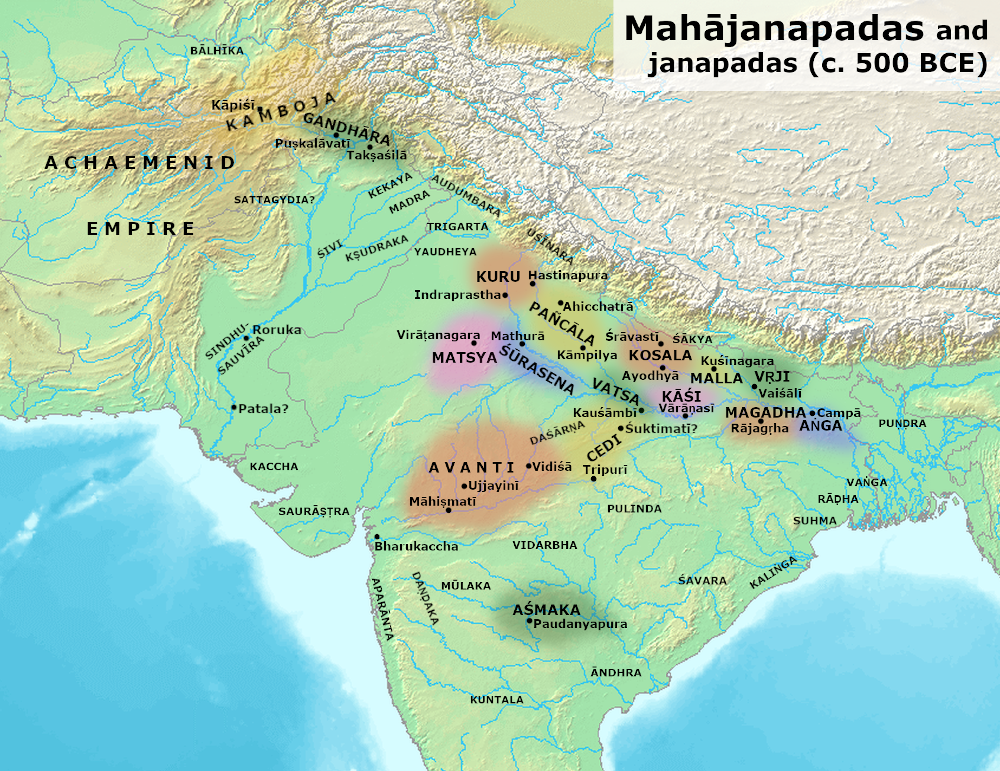
Magadha's rise to power in the Gangetic plain is the first major example of a territorial empire. A major reason for its rise could be its quick annexation of its neighbouring mahajanapada Anga - see Image [2]. It is theorized that the control of iron ore mines (in modern-day Jharkhand) was crucial to Magadhan military dominance in the Iron Age (Northern Black Polished Ware culture). By eliminating Anga early on, they eliminated the only competition for these mines.
Magadha consolidated power under Ajatashatru, Shishunaga and the Nandas. The Nandas had built up a major army, trade network and roads, all of which were inherited by the Mauryas.
Mauryan territorial expansion happened in two major directions
Contrast this with the Huns/Hepthalite invasions during the Guptas, the Kushan and Shaka invasions and subsequent empires in the Northwest, the Ghurids/Ghaznavids raids, Timur bringing the Delhi Sultanate to its knees, or Nadir Shah/Ahmed Shah Abdali removing what little power and wealth the Mughals possessed.
This implies a lack of control over swathes of territory which are now included under Mauryan land, including the forested interiors of what is now Maharashtra, Chattisgarh, Orissa etc. Some of Ashoka's inscriptions include references to avijita (unconquered) neighbours and atavi forest tribes within his territory, suggesting that his empire was not as spatially vast as suggested.
India has subsequently seen three waves of territorial expansion which saw most of the subcontinent united (but not all of it) - The Guptas, Khiljis/Tughlaqs and the Mughals.
Developments between the Mauryas and The Guptas
The major difference between the pre-Maurya period and post-Mauryan period is the rise of regional powers and the formation of the first distinct languages, cultures and states in the Indian subcontinent.
As dialects of Prakrit began to separate, we see the rise of a common culture creating a sort of 'identity' for several regions, and these regions would soon begin resisting assimilation into larger kingdoms. Kalinga is a good example of the same, with Kalinga creating the most resistance for the Mauryan empire.
The Guptas
We know a great deal about the great Gupta ruler Samudragupta because of an inscription chronicling his conquests - the Allahabad pillar. There are clear descriptions of the tribes, kingdoms and territories Samudragupta conquered.
Samudragupta led an expedition which defeated several kingdoms along the eastern coast of India. The southernmost kingdom mentioned in the pillar is Kanchipuram, in modern-day Tamil Nadu. However at the end of each battle, he reinstated the kings and showed mercy. The belief is the empire was too large to control effectively and it was more pragmatic to leave the governing to local kings. The benefits included the opening up trade routes and ports to the Guptas.
Samudragupta also explicitly mentions some tribal kings of central India's forests who are his 'servants'. The exact extent of control of the Gupta empire over the tribal areas is debatable, but it is clear that Samudragupta engaged with them to a limited extent (which is more than we can say about the Mauryas).
To match the southern reach of the Mauryas, the Guptas had to compete in the Southward expansion with the Vakatakas, who controlled the Deccan. Instead of attempting to conquer them, Chandragupta II chose a diplomatic marriage forming an alliance. This alliance effectively created a Gupta-Vakataka power bloc which extended from the Himalayas and the Hindu Kush to the northern Deccan. However, this Vakataka territory is not counted as Gupta territory in records.
The Delhi Sultanate - Khiljis and Tughlaqs
Alauddin Khilji and his general Malik Kafur raided as far south as the Pandya kingdom. However, the Khilji dynasty disintegrated soon after these campaigns and were replaced by the Tughlaqs.
Under Muhammad bin Tughlaq, the Delhi Sultanate reached its territorial zenith. However, a combination of religious zealotry, bone-headed military excursions depleting the treasury and excessive taxation would prove to be his undoing, losing most of the territory gained south of the Vindhyas within 15 years of its conquest.
The Mughals
The Mughals came closest to the Mauryans in the sheer size of the empire. They did this by having the most centralized administration since the Mauryans. They also enjoyed a greater degree of control over their empire than any other administration in Indian history (up to that point) by virtue of the mansabdari system.
However, what brought Aurangzeb and subsequent rulers down was the combination of religious zealotry (alienating warriors like the Marathas) and excessive military campaigning bankrupting the empire.
The Mauryans might have had the largest empire in Indian history on paper, but the true extent of their control is nebulous and it can be debated if they were the largest empire of the great empires of India or the one with the southernmost reach.
However, reasons for the success of their empire vis-a-vis future empires may include
That said, I would argue that the Guptas and Mughals enjoyed greater control over their empires and rivaled the Mauryans in territory, after Mauryan territory is revised downwards to reflect the true borders of the empire.
In any case, all three empires had lax control over their southern territories and their dominance over the southern territories did not last for more than a generation or two.
[1] A map of Mauryan territory - its major cities, boundaries, trade routes, edicts and pillars. Also includes a boundary of Nanda territory. https://i.imgur.com/8tyYzyv.png
[2] Map of the 16 Mahajanapadas: https://upload.wikimedia.org/wikipedia/commons/2/28/Mahajanapadas_%28c._500_BCE%29.png
[3] A History of India - Hermann Kulke and Dietmar Rothermund (Source of Image [1])
[4] Romila Thapar - Aśoka and the Decline of the Mauryas
[5] Romila Thapar - The Mauryas Revisited
[6] Romila Thapar - A History of India, vol. 1: From Origins to 1300
Romila Thapar is easily the best source for all things Mauryan
I wasn't sure I'd actually get any answers about this, but I've got several good answers. Thankyou to everyone who contributed!