I am far from an expert on this, but I studied Urban Geography and Transportation in college as a second major (which I never completed), so I can shed some light on the subject.
First, understanding where the roads actually came from helps. Original roads in the us were constructed as wagon trails, trading routes, footpaths that later became trails between towns, and for a variety of other reasons. The roads weren’t maintained by the government as all overland shipping and long-distance travel took place on the railroads.
As cars became more popular, however, people created auto clubs and would promote certain routes. Doing sow would allow them to collect sponsorships and payments from businesses along those routes. The end result was a series of auto-trails that often made little sense (The Custer Battlefield Highway ran from Des Moines, Iowa to Glacier National Park, Montana). Anyone could create an auto-trail, go out and put their emblems up along it, and then say it was a highway, yet no one actually maintained the routes and in many places in the west you’d be lucky to find a highway at all when you got there. Additionally, the problems between multiple routes between the same cities arouse as competing auto clubs promoted separate trails. The end result would be “roads” that went hundreds of miles out of their way to connect to towns willing to pay the club for promoting the trail, but it would be far from the most efficient route. Additional, as no one actually owned the roads, you could have fifteen different trails using the same stretch of road and all calling it fifteen different names.
To solve all of this, a series of national meetings were held in 1925 and it was decided that the highways would be numbers as part of one national interstate system. Interstate does not refer to freeways in this case, it just simply means that the highways ran nationwide. Many portions of many named auto-trails were deemed to be unimportant and left off the final plan. States fought over the routing of the highways, not wanting to be “left off the map”, and they fought over the numbers bitterly, as numbers that ended in 0 or 5 were considered more important.
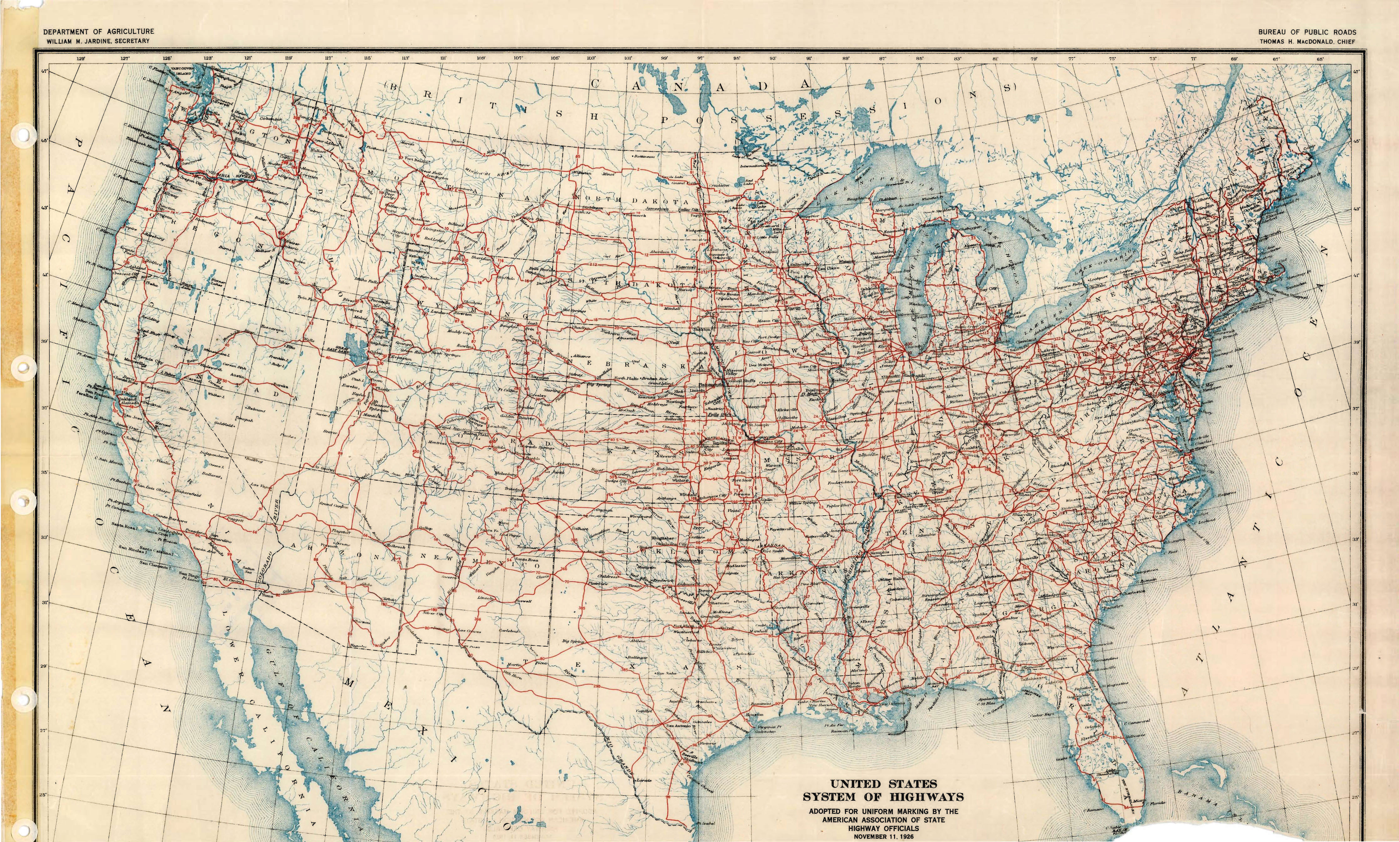
The reason I give the early history of America’s roads is to illustrate that we already had a comprehensive albeit extremely poorly maintained network of roads in the country. When the US Route system was laid out, the problem facing planners wasn’t where to construct the highways but which ones to leave out of the network. Once the network was set, it connected the nation quite well, and over the next several decades those highways were improved, paved, and maintained. By the time the interstate construction began, America had a functioning road network. Here is a map of the US Highway system in 1926, the first year it was numbered:
http://wchsutah.org/maps/1926us.jpg
By in large, the Interstate System followed existing routes. More so out east, these new interstate highways were constructed as new roads that ran parallel to older routes. The buildup of residences, intersections, towns, and businesses were the main factor in the need to construct new routes completely separate from the old highway. It just wasn’t feasible to buy up all the property along a road and widen the highway to interstate standards. An example of this is interstate 90 in Western New York State. It parallels the old US-20 from Buffalo on down to Cleveland, Ohio, but never actually uses in of the original route even though it is always within a couple of miles of the old road. Over 75% of the interstate highways were constructed as completely new roads, but they were almost always in parallel to some sort of existing route.
https://www.google.com/maps/@42.4030347,-79.5182191,10.77z
As the interstate system stretched towards the western part of the country, existing routes were turned into interstates. The roads out west often ran for miles and miles without having so much as a driveway intersecting them, so it was really easy to just upgrade the existing highway, lay down two additional lanes in parallel to it, and then bypass the towns as needed. Green River, Wyoming, is a terrific example of this. In the map below, you see I-80 approaching Green River, Wyoming, from the East. This used to be US-30 (technically it still is, as US-30 and I-80 share the same stretch of highway there). US-30 splits off at the exit and enters the town of Green River from the East. This road is named Flaming Gorge Way, but it also carries the emblems Business-80, indicating that this is a street through a populated area that is bypass by the interstate. While these business routes might be viewed as helping local business (since you can use the address and indicate that you are near an interstate highway), they were originally created because stretches of interstates were first built between towns, and then bypasses were slowly built around towns as part of a second phase. The business-I-80 route, in this case, would allow travelers along I-80 to use the constructed portions of I-80 and then still drive through Green River without “leaving the interstate” even though the actually interstate wasn’t yet constructed.
https://www.google.com/maps/@41.5240115,-109.5017758,13.25z
Now, in terms of whether there was a road there at all before the interstate, the answer is almost completely yes. The interstate highways were built to connect the busiest parts of the country, and all of these places already had some sort of road connecting them. The Interstates simply replaced the previous road. This being said, there were some parts of the country where major deviations were made. In Arizona, Interstate 40 was built to parallel what was then US-66, but east of Kingman, the highway engineers decided to significantly deviate from the US-66 route to save time and distance. I-40 was built several miles to the south which effectively wiped several small towns, most notably Peach Springs, Arizona. In the movie Cars, the town of Radiator Springs was based off of Peach Springs.
https://www.google.com/maps/@35.2867493,-113.5917968,10.8z
Only in vary rare instances was a highway constructed as a completely new route. One example of this would be I-70 through Utah. Originally, I-70 was supposed to have its Western terminus in Denver. It was then decided that it would pass through the Rocky Mountains in Western Colorado and connect with Salt Lake City, paralleling US-6. Before construction began, however, the military decided that they needed Denver to connect with Southern California more than they needed it to connect to Salt Lake City, so the highway was routed towards the Southwest. You can see the original plan which called for I-70 to end in Denver here:
https://www.cambooth.net/project-1947-interstate-highways/#jp-carousel-2372
Additionally, this road map from 1950 Utah clearly shows no highway anywhere near where I-70 runs between Green River, Utah, and its current western terminus at I-15 in Cove Fort. Utah Route 24 was an “unimproved road” at the time (dirt road that wouldn’t receive a lot of maintenance), and it ran well to the South of where I-70 now runs.
https://www.davidrumsey.com/luna/servlet/detail/RUMSEY812121545500254:Shell-Highway-Map-of-Utah-;JSESSIONID=758476f4-4ad7-4c5d-a4d1-e5730891b863?showTipAdvancedSearch=false&showShareIIIFLink=true&showTip=false&helpUrl=https%3A%2F%2Fdoc.lunaimaging.com%2Fdisplay%2FV74D%2FLUNA%2BViewer%23LUNAViewer-LUNAViewer&title=Search+Results%3A+List_No+equal+to+%275840.077%27&fullTextSearchChecked=&dateRangeSearchChecked=&advancedSearchUrl=https%3A%2F%2Fdoc.lunaimaging.com%2Fdisplay%2FV74D%2FSearching%23Searching-Searching&thumbnailViewUrlKey=link.view.search.url
Even today, these patterns are still being played out. Interstate 69 is being constructed between Indianapolis and South Texas. The portion between Evansville and Indianapolis is being constructed as a completely new highway that parallels Indiana State Routes 37, 45, and 57, whereas Interstate 11, which is being constructed between Las Vegas and Phoenix, is being built by utilizing existing US-93 and bypassing towns as needed. No current highway proposal, plan, or construction is being done as a new road connecting two areas that aren’t already directly connected by a direct or mostly direct route of some roadway already.
I-69 in Southern Indiana: https://www.google.com/maps/@38.557949,-87.5847177,9.53z
I-11 in Arizona and Nevada: https://www.google.com/maps/@35.9190809,-114.7533541,11.56z
Additional Sources: https://www.fhwa.dot.gov/infrastructure/numbers.cfm
Route-66 is the most famous example of this. It was one of the main transcontinental routes before the interstate highway system.
https://www.nps.gov/nr/travel/route66/maps66.html
This is a great resource from the National Park service that shows the old route vs the current interstate system.
They tried to expand as much of the route-66 road bed as possible, however there were certain areas where this just wasn't possible. Interstates need to be much straighter and wider.
I can testify large parts of the famous Route 66 are now local roads. I used to live on it!
You can still see the old brick parts of Route 66 running alongside the current one. No stealing bricks, though, they do pay attention.