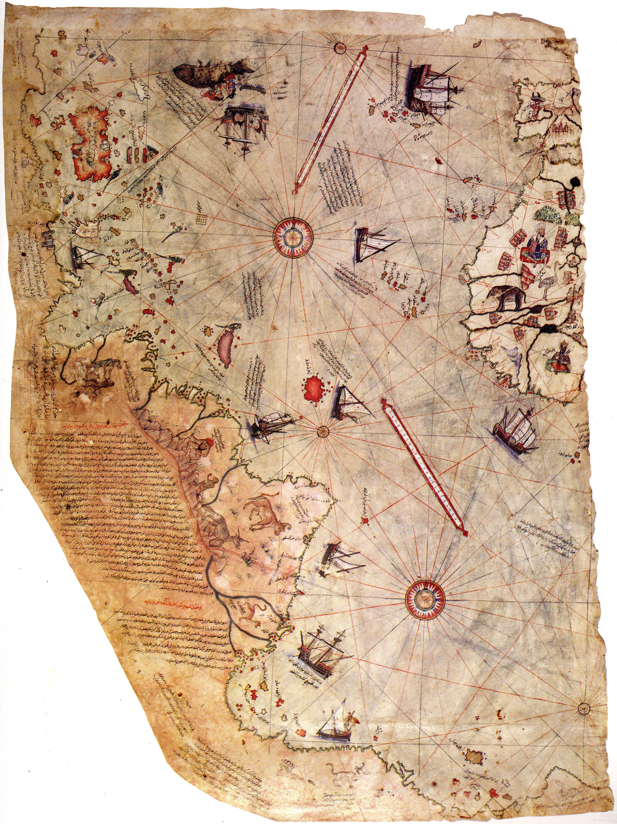
I read about this interesting piece of document called Piri Reis map. It's basically a world map from 1513, made by Ottoman carthographer Piri Reis. What's interesting is that it supposedly shows coast of Antarctica, centuries before it was discovered. Is this a fact, and if it is, what could be the explanation? Were the Ottomans really that far out, or perhaps Ancient Aliens? (sarcasm, obviously). Thank for any explanation!
The Piri Reis map of 1513 (reference image) is an interesting document. It is one of the oldest existing documents that depict the New World.
First, there is no evidence that the Ottomans ever made it across the Atlantic Ocean in the 16th century. Piri Reis compiled information from existing documents to create his 1513 world map. In the long inscription to the left of Brazil, he says that he used twenty sources, some from ancient Greece, an Arab map of India, four Portuguese maps of the Indian subcontinent and China, as well as a map of the Americas drawn by Christopher Columbus. So to answer your first question, it is extremely unlikely that the Ottomans explored any portion of the New World by 1513.
Now, does the Piri Reis map depict Antarctica? It is unlikely. Recall that in 1513, the southern Atlantic coast of South America was basically unknown to people in Europe and Asia. The first attested exploration of that area happened in 1520, on Magellan's circumnavigation. Piri Reis claims to have constructed the Americas portion of his map from a source by Columbus, as well as assorted charts from Portuguese sources mapping the coast of Brazil. We know that Columbus never voyaged as far south as what is today Argentina, and there is no evidence the Portuguese mapped what is now the coast of Patagonia before 1520.
Furthermore, Piri Reis's world map is reasonably accurate, especially in its placement of Brazil with respect to Africa and Europe. This denotes a decently good understanding of the position of the Brazilian coastline, which he gained from his aforementioned Portuguese sources. However, if we assume that Antarctica is shown at the bottom of the map, then it is very misplaced compared to the rest of the map, depicted hundreds of kilometers north of its actual location. This betrays a lack of understanding about where Antarctica is, and it is far more reasonable to conclude that Piri Reis did not know of Antarctica's existence, rather than that Piri Reis knew of Antarctica and deliberately mis-placed it for any reason. It's far more likely that he was following a mapmaking convention of placing a hypothetical landmass in the Southern Hemisphere (a "terra australis incognito").
An unrelated nerd-out sidebar: The early 1500s were an exciting time for the Ottoman Navy. With the conquest of Mamluk Egypt in 1517, the Ottomans gained access to the Red Sea, the Persian Gulf, and lands east in the Indian Ocean. There was desire for naval knowldge of lands not yet explored by the Ottomans, in order to aid in general knowledge, trade, and military planning. Piri Reis would later go on to create the Kitab-I Bahriye (Book of Naval Matters), a book containing 210 naval charts intended for use by mariners and the Ottoman war fleet. Later in the 16th Century, the Ottomans would come into conflict with the Portuguese for trade supremacy in the Persian Gulf and the Indian Ocean. It's an exciting chapter in Early Modern history that's frequently overlooked. Giancarlo Casale's The Ottoman Age of Exploration is a fantastic read about this time.
Sources:
Casale, Giancarlo. The Ottoman Age of Exploration
Soucek, Sven: "Islamic Charting in the Mediterranean", from The History of Cartography, Volume 2, Book 1