I was reading today about the stupendous achievement that is the Pont du Garde at Nîmes, which was so precisely engineered that it descends only 12.6 meters over its entire length, for an average gradient of 1 in 3000. I know there are many other examples of such excellent early hydro engineering - the Indus river valley civilization had indoor plumbing in 2300 BC - but this got me thinking - how would ancient societies measure something like elevation?
I have a general awareness of the techniques surveyors would have used to lay out the courses of such aqueducts - basically, combine visual sight lines, trigonometry, abundant labor, and the inchworm method to lay everything out in as fine detail as necessary. Maybe this is just the answer? But I keep thinking that ancient societies would have needed to have some concept of relative elevation in order to know whether a certain water source could even be made to serve a given city in the first place prior to doing all the backbreaking work of surveying.
I know that in the 1800s, people like William Henry Brewer hauled massive barometers up to the top of mountains and used measurements of atmospheric pressure combined with trigonometric calculations and sightings to estimate the heights of the peaks. But AFAIK, the concept of atmospheric pressure only goes back to Torricelli in the early 17th century.
Does anyone have a better answer here? I'm open to being told that the answer is just pretty boring - they measured lots and lots of angles. But I wondered if there was more to it than that.
The Romans had no good way to measure absolute elevation (i.e. height above sea level). They occasionally attempted to measure the height of mountains; but since they did not have barometers (or any concept of atmospheric pressure), they had to rely on rather haphazard trigonometric methods.
When it came to aqueducts, however, it was relative elevation that mattered - and this the Romans could determine fairly accurately. Once an aqueduct's source had been located, surveyors (often detached from the nearest convenient legion) began by tracing a route to the city. Typically, this route followed the contours of the land; the object was to keep the aqueduct channel subterranean, often following natural ridge lines, as long as possible.
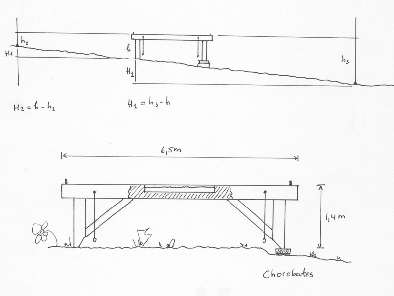
To determine gradient (and thus elevation differences), Roman surveyors used two instruments: the chorobates and the dioptra. Vitruvius describes the chorobates in these terms:
“The chorobates is a rod about twenty feet in length, having two legs at its extremities of equal length and dimensions, and fastened to the ends of the rod at right angles with it; between the rod and the legs are cross pieces fastened with tenons, whereon vertical lines are correctly marked, through which correspondent plumb lines hang down from the rod. When the rod is set, these will coincide with the lines marked, and show that the instrument stands level. But if the wind obstructs the operation, and the lines are put in motion, so that one cannot judge by them, let a channel be cut on top of the rod five feet long, one inch wide, and half an inch high, and let water be poured into it; if the water touches each extremity of the channel equally, it is known to be level. When the chorobates is thus adjusted level, the declivity may be ascertained.” (8.5.1–2)
There is a handy illustration of a chorobates here.
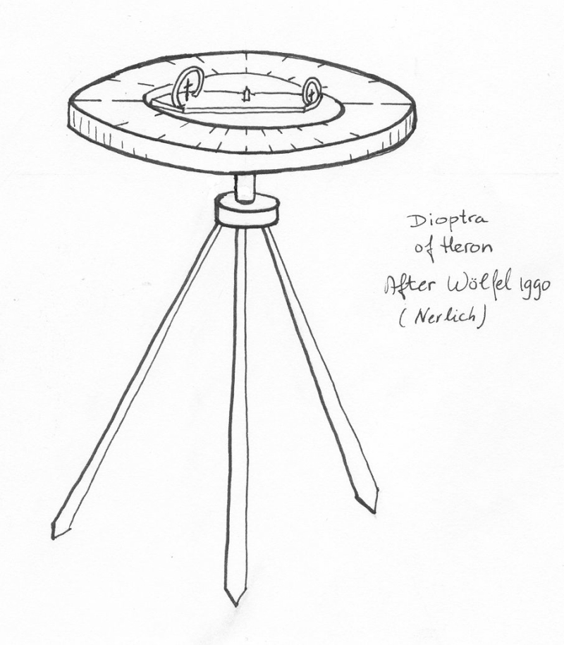
A dioptra was used to measure the distance and height of features in the landscape. This was basically a primitive theodolite - to quote the description from the New Pauly article on the topic, a simple dioptra was "a ruler equipped with a builder's level and a metal tile with a viewing hole attached to one end (‘eye piece’). Another metal tile could be moved by the observer up and down a groove in the ruler. Focusing on the object to be measured through the viewing hole, the movable metal tile is pushed to the point where it obscures the observer's view of the object. After reading the measurement from the ruler and noting the measurement from the movable metal tile it was then possible to determine the angle or the apparent distance using Hipparchus' chord tables.” Since a dioptra was less unwieldy than a chorobates, this was likely the instrument used in the tunnels that made up most of an aqueduct's length.
An illustration of a (different kind of) dioptra.
With these and similar instruments, Roman surveyors could, albeit slowly and painstakingly, determine the elevation of a planned aqueduct’s sources and the slope of its channel.