There have been many posts about the "longitude" problem and the steps it took to solve it. I just finished reading "Longitude" by Dava Sovel, which was a delightful book on the subject. However, one seemingly trivial piece of the puzzle kept stumping me. In order for the chronometer method to end up providing an accurate measurement of the longitude, you need to be able to know the time at a given common locale (hence the chronometer keeping track of say, Greenwich time), but you also need to know exactly what the local time of solar noon is on that day. You need to be able to know relatively precisely when solar noon occurs for the comparison of the local time to the chronometer to yield an accurate result. My question is: how were sailors able to precisely determine solar noon to within <60 second accuracy (which is implied in the book)?
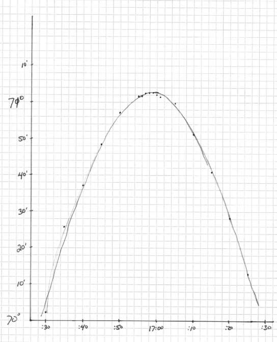
Local solar noon is when the sun is at the highest altitude (angle) above the horizon. An example of the path of the sun in the sky:
The problem is that the angle above the horizon changes very slowly close to solar noon, so you need to measure the angle and how it changes over a period of time. The angle is measured with a sextant.
First, the relatively modern method, widely-used in the 20th century pre-GPS, and still used today. To cope with the slow change of angle close to noon, the usual rule of thumb is that you should measure from about 30 minutes before noon to about 30 minutes after noon. One way to convert these measurements to find solar noon is to plot them on a graph, which will give an approximately parabolic curve:
There are few different ways to find the peak of this curve. Simple and accurate is to find the mid-point between the left and right sides for some different heights up and down the curve. This can be done with dividers, as described in
In the electronic age, the times and angles can be entered into a calculator or similar (today, even a smartphone app), and the best-fit parabola mathematically found, giving a more accurate result.
It is also possible to do similar measurements with stars at night, provided that you know the time when it should be at the highest angle in the sky (which you look up on a table in a book, or today on a computer).
The older technique (which predates the marine chronometer) is essentially a simpler version of this. The key point is that the time of noon - the peak of the parabolic path of the sun - lies halfway between the left and right hand sides of the curve. The simplest measurement that gives this halfway point is to measure the times of two points with equal angles, one on the left an one on the right. Mid-morning, measure the altitude of the sun and record the time. Mid-afternoon, record the time that the sun descends in the sky to that same altitude. This is called taking a "time sight". You still want the angle of the peak of the parabola, to determine latitude, so you still measure that (taking a "noon sight").
The more modern version, with either graphical fitting of a parabola to the points, or mathematical curve-fitting, essentially averages the error over a sequence of time sights, providing a more accurate result. This allows the navigator to take advantage of more accurate more modern clocks. With a less accurate chronometer, there is less benefit, so the time sight with two measurements at equal altitudes was usual. This method was still appearing in navigation manuals into the 20th century:
Before the marine chronometer, this method could still be used, with the accurate time provided by lunar tables and observations of the moon.