Was it inhabited predominantly by Egyptians, to protect British interests in the Suez canal, to deny it from Israel and/or Jordan or something else?
The Sinai Peninsula was officially delineated as part of the Egyptian Khedivate in October 1906, almost half a century before decolonization began in the aftermath of the Second World War.
Essentially, following a dispute over Taba, a coastal town on the western shore of the head of the Gulf of Aqaba, that began in January 1906 and that threatened a military confrontation between the British and the Ottomans, an Egyptian-Ottoman boundary commission negotiated what they called a “separating administrative line” along the eastern edge of the Sinai Peninsula—more or less from Rafah to Taba—as the official eastern boundary of the province of Egypt, which was at the time (a) part of the Ottoman Empire, but also (b) semiautonomous with a hereditary dynasty governing its own state system, while also (c) under British occupation since 1882.
The main reason the boundary was drawn that way, according to the prevailing academic literature on the topic, was due to inter-imperial rivalry between the British and the Ottomans. This rivalry flared up in 1906 when the British became concerned about potential Ottoman expansion of the Hijaz Railway to Aqaba, which stirred Ottoman worries about potential British intrusion in the Sinai region.
So, when British and Egyptian officials went to Taba in January 1906 with the intention of setting up a police station, they found Ottoman troops already stationed in Aqaba and were told to leave. After they withdrew, the Ottoman troops promptly occupied Taba, which triggered a naval and diplomatic standoff that lasted until May 1906 when the Ottoman state acquiesced to a British ultimatum and agreed to an Egyptian proposal to form a boundary commission and settle the Sinai question.
For the Ottomans, they wanted to limit British encroachment and ensure that Egypt would not be severed from the Ottoman Empire, and so they tried to establish a direct presence in the Sinai as a way of reasserting Ottoman sovereignty in the region. This was not the first time they tried this; there was an earlier attempt in 1892, and while tense it was not as contentious as in 1906.
For the British, who were managing what they called a “veiled protectorate” over Egypt at the time—the primary reason being to protect the interests of European creditors who owned much of Egypt’s debts—they wanted to keep the Ottomans from having any direct administrative control over or military access to the Suez Canal and Egypt, as well as the Nile valley more broadly. This was not just about protecting their financial stake in the Suez Canal (the British owned 44 percent of shares in the Suez Canal Company since 1875), having an eye over global commerce, and ensuring the safe passage to and from India, but also about maintaining the international arrangements that justified the British occupation of Egypt and even pushing back against Ottoman territorial claims in the Red Sea area, such as the Anglo-Egyptian condominium over Sudan. To these ends, the Sinai acted as a natural buffer.
But it was not just the immediate events of 1906 that ultimately made the Sinai part of Egypt. There were also significant intra-Ottoman reasons the Egyptian state, independent of British interests, wanted the Sinai formally recognized within the Ottoman state system as part of the province of Egypt, reasons that had developed over many decades since the mid-nineteenth century.
By the turn of the twentieth century, the modern Egyptian state had long regarded the Sinai as its administrative responsibility, which was reaffirmed to Muhammad Ali Pasha (or Mehmed Ali Paşa, if you’re an Ottomanist) in 1841 when he was recognized as the founder of a hereditary dynasty governing Egypt as a semiautonomous Ottoman province. The Egyptian delegation to the boundary commission, which included both British officials as well as Egyptian representatives of the khedive, argued during the 1906 negotiations that Egypt had been dutifully performing the functions of empire in the Sinai on behalf of the Ottoman state. These included (a) safeguarding the land route to Mecca for the annual pilgrimage (a longstanding administrative role that Egypt-based states fulfilled but which became increasingly obsolete by the 1870s with the rise of the faster steamship route traversing the Red Sea), (b) establishing frontier posts and police stations, and (c) taxing the Bedouin inhabitants of the peninsula, taxes that contributed to the tribute sent to the Ottoman state coffers.
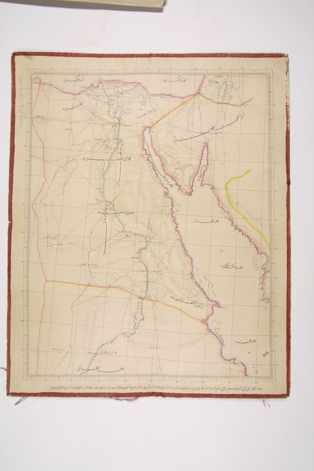
The Ottoman commissioners responded by invoking the authority of an 1841 map (image taken from the website of the Ottoman History Podcast’s episode 423), often called the “first map of modern Egypt.” This map outlined Egypt’s eastern boundary as a line from Suez to the northeastern corner of the Sinai Peninsula (most likely Rafah, but it is not marked on the map), giving Egypt only a small triangle in the northwest of the peninsula with the bulk of the Sinai attached to the province of the Hijaz. However, that map was lost at the time of the boundary negotiations, and the British and Egyptian commissioners countered that the Egyptian state was nevertheless authorized on numerous occasions by the Ottoman state since 1841 to manage the affairs of the Sinai Peninsula in lieu of direct Ottoman administration. The reality on the ground that had developed over decades of continuous Egyptian administration, they argued, meant the Sinai should be formalized as Egyptian territory.
Ultimately, the British and Egyptian boundary commissioners got their way as the Ottoman representatives failed to make a convincing case that there had been any longstanding direct Ottoman presence in the Sinai to warrant a boundary that would cede any part of the peninsula to another Ottoman province that was under the direct administration of the centralizing Ottoman state.
The main concession the Ottoman state received was the assurance that this boundary was an internal, administrative line and not a border severing Egypt from the Ottoman Empire. That said, the British made sure to include a clause in the final agreement barring Ottoman troops from crossing west of the line into the Sinai, a direct limitation on the sovereignty of the Ottoman state.
With that, the negotiations ended, the delineated line was mapped out, the boundary agreement was signed in Rafah on October 1, 1906, and in the months that followed the line was physically demarcated (though not always accurately) with telegraph poles at first before stone boundary pillars replaced them.
So, if I can interpret your question broadly as “why was the Sinai given to Egypt?,” or rephrase it as “why was the Sinai territorialized as part of Egypt?,” then the answer is two-fold: In the course of British-Ottoman imperial rivalry over Egypt, the British were determined to establish the Sinai Peninsula as a buffer preventing the Ottomans from establishing any degree of direct administration over or having military access to the Suez Canal, the Sinai, and Egypt; and in the context of Egyptian relations with the Ottoman state as a semiautonomous vassal, the Egyptians were determined to formalize an administrative reality over the Sinai that had developed during the latter half of the nineteenth century. For both the British and the Egyptians, preserving Egypt’s position within the Ottoman state system was necessary toward securing their respective interests.
[Edit: fixed spelling and grammatical errors; added some clarifying detail in final paragraph.]