My experience is primarily within Roman Italy, so my answer will only speak to that world; other experts will surely have different information!
If we look at the earliest foundation of settlements in Italy - primarily in the Early Iron Age (ca. 10th-8th c. BC; not implying the Iron Age ended at this stage, just focusing on the Early phase), settlements were primarily located in areas with good defensibility, which means on raised platforms like hills and such. In central Italy specifically, the volcanic landscape provides a lot of plateaus which are excellent for these early settlements - their height allowed the residents to keep an eye out for any invaders or other dangers. Second, we tend to find settlements at this period on the larger plateaus since this appears to be a time when smaller settlements, prevalent in the Bronze Age, coalesced into larger settlements - giving rise to what we call cities within a few centuries. The size of the plateau is important because we're looking at groups that were previously independent - whether they were small villages, kin-based groups, etc - coming together in agreement to live as a single community. The earliest settlements show these groups on a single plateau but separate from one another, almost like neighborhoods, indicating there was still a degree of stand-offishness among them, before time did its work and melded the disparate groups into a larger, more cohesive community.
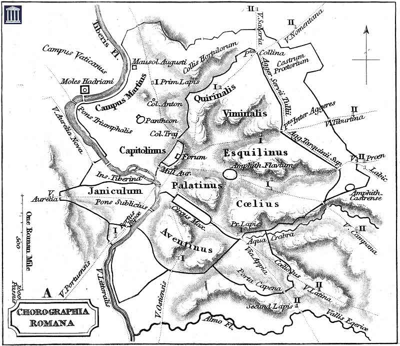
So, the location of an appropriate plateau is probably one of the main considerations. I'm thinking here of settlements that later became cities, such as Veii, Volterra, Cerveteri/Caere, among others. Rome is a little different in that it didn't have one major plateau available, but did have several hills (they defy counting, in reality - even in antiquity the number of Rome's hills, and which were 'official,' changed over time (Amanda Claridge's Oxford Archaeological Guides: Rome has a good overview of the hills/ridges and the ancient difficulty in numbering them on pages 3-5) - but of course the famous number is seven hills) and a few were selected for the earliest habitations. In the 10th-8th centuries, these are primarily found on the Palatine and Esquiline hills, near to the Tiber River. Pompeii doesn't have a commonly agreed-upon date for its founding - there is an explosion of resource-expensive building activity in the 6th century that argues for a foundation date at least contemporary with it, but certainly it's earlier - but similar conditions existed here: there was a large rock outcropping on the coast with the Tyrrhenian Sea and bordered immediately to the south by the Sarno River (the exact location of which in antiquity isn't known, owing to the amount of debris from the AD 79 eruption which altered the course of the river & the coastline), which allowed for defensibility, great views from far away (allowing the early city to project a message of strength - that is, "don't mess with us" - to any in the vicinity), and a controlling of traffic along the river. Rome had a similar raison d'etre - situated at a bend in the Tiber with an island that allowed for easier crossing here than anywhere else, Rome's position allowed it to control river traffic moving inland from the nearby (ca. 10km) sea.
It's important to know, though, with this group of settlements specifically that they would have extended across the river bank once it was safe to do so. Rome spread to the area across the Tiber - in Latin, Transtiberim, 'across the Tiber,' but Italian Trastevere, 'across the Tevere,' the modern name for the river - somewhat early in its history. There are references in Roman historical sources - Livy and Dionysius of Halicarnassus, specifically - to farms owned in this area by the 6th c. BC war hero Mucius Scaevola (the Prata Mucia), and the 5th c. BC dictator Cincinnatus (the Prata Quinctia). This is a great illustration of the pattern we see in lots of other Italian settlements - farmland, of course, that was for more than subsistence use had to be outside of the city proper, and would also be outside of any fortifications, so agricultural land is often the first use of land we see moving beyond the core of any would-be city. As that city grows, though, as long as it is relatively safe from attack, it will need to expand into that land and so will start to build other things there - in ancient Italy, this would be temples, roads, housing (both for those without means to live in a safer area and the wealthy who wanted expansive grounds), and burial grounds. Owing to Rome's growth and the fact that it began conquest of the neighbors with whom it had previously battled - i.e. the cultures and settlements that would have threatened it in its earliest years, such as the city of Veii to the north, the Etruscans more generally, etc - that added safety would surely have encouraged them to build more intensively across the river, thus ending the idea that Rome was one one bank of the Tiber somewhat early on. I should also point out that this was probably the case for Pompeii as well, but our knowledge of the city is primarily focused within its walls. The change to the topography following the AD 79 eruption and modern settlements around the ancient city make learning more about how & when Pompeii used its territory - and therefore, how it used the land immediately to the south of the Sarno river and when it began to do so - very difficult, but the suburban (?) site of Moregine, the sanctuary at Fondo Iozzino with pre-Roman traces, etc all point to significant use of the territory to the south of Pompeii.