I am reading the Ulysses S. Grant memoir and having a hard time comprehending or finding more info on how he describes the city in this passage. Literally built on planks over the water?
“In 1853 the town had grown out into the bay beyond what was the end of this wharf when I first saw it. Streets and houses had been built out on piles where the year before the largest vessels visiting the port lay at anchor or tied to the wharf. There was no filling under the streets or houses. San Francisco presented the same general appearance as the year before; that is, eating, drinking and gambling houses were conspicuous for their number and publicity. They were on the first floor, with doors wide open. At all hours of the day and night in walking the streets, the eye was regaled, on every block near the water front, by the sight of players at faro. Often broken places were found in the street, large enough to let a man down into the water below. I have but little doubt that many of the people who went to the Pacific coast in the early days of the gold excitement, and have never been heard from since, or who were heard from for a time and then ceased to write, found watery graves beneath the houses or streets built over San Francisco Bay.”
The north end of the San Francisco peninsula - particularly in the area of the Marina District, has evolved considerably from its pre-Gold Rush configuration. With the Gold Rush of 1849, hundreds of ships arrived with fortunate seekers. Unfortunately for the ship owners, the sailors typically abandoned their former career, joining those who sought for gold.
This resulted in many abandoned ships along the long wharfs that extended north into the Bay where it was by nature rather shallow. Lacking crews, the ships were worthless as ships, but they did provide a peculiar form of Gold-Rush-era real estate. Entrepreneurs set up businesses in the abandoned vessels, and in at least a few cases, business owners arrived with large collections of goods to be sold and set up shop on the Wharf, selling out of their ships, which now served as a business front.
Fire occasionally swept through the district, burning ships down to the water line. The solution at that point was to back fill the wrecks to provide something akin to land upon which new businesses could be built.
Standing on the hills overlooking north San Francisco, it is easy to see how the old coastline is marked by the edge of the hills, the flat land marking the region where ships were once moored. As a young officed. U.S. Grant had been on the West Coast in the first stages of this transformation. He no doubt would have recognized the dramatic change during his post-administration "World Tour," arriving in San Francisco in 1879.
This peculiar origin of the Marina District makes it particularly vulnerable to earthquakes. The "land" such as it is, is soaked with water, and in an earthquake, it is prone to jiggling as one might image a bowl of Jello being shaken.
While Grant probably exaggerates a bit about people falling off them into watery graves, there were buildings mostly on the north and east side of it that for a time were basically built on piles placed over mud or relatively shallow water.
The best way to illustrate this is with a picture of the geology of present day San Francisco. White indicates solid land of some sort, which for a good chunk of the western part of the city until the 1890s were sand dunes.
Green, however, indicates something else - that the land was originally underwater. From Delgado's Gold Rush Port:
"San Francisco was ill-equipped for its new status as the principal American port on the Pacific. Crowded beyond its capacity, the small settlement was hemmed in on three sides by huge, sifting sand dunes and by a shallow 6- to 18-foot-deep, 336 acre cove. The cove was a stagnant pond of thick, foul mud at low tide. The city met the demands of growth by moving out across the mud flats and then into deeper water. Starting in 1847, the city fathers subdivided and sold the flats in front of the town as "water lots"...'all contained between the limits of low and high-water mark; and four-fifths of them were entirely covered with water at flood tide.'"
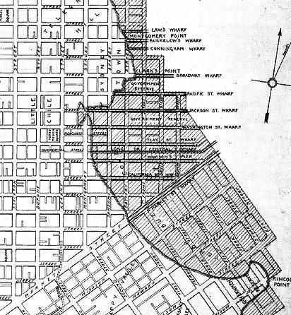
Part of this was pure greed for the city fathers; nothing like making money selling plots of land that didn't exist yet! But one of the two other issues were that the port was completely inadequate for the sheer amount of cargo and people coming in; in the late 1840s it basically was a beach offramp to Portsmouth Square, where the present day Transamerica Pyramid (that big triangle building that shows up in photos of San Francisco) currently stands, which is roughly the little finger of white land jutting out into the green at the eastern end of "Geary Boulevard" on the map. Port facilities (and bars, and entertainment) begin to creep out into the bay, which you can see illustrated a bit more closely here with the various wharves built.
The other, though, was that construction supplies were immensely limited. Kevin Starr talks about this a bit, with one of San Francisco's first ministers, Methodist William Taylor, building his own house from wood he'd logged himself (he preached to the loggers in Marin while doing so), and another having lumber shipped around the horn from Maine to build one of the first churches in San Francisco (Presbyterian, of course; the whole point was to establish New England morality in what was already known as a den of iniquity!) This, incidentally, creates an entire economic ecosystem to supply the boomtown, with lumber milled and shipped all the way down the coast from as far away as British Colombia; this had significant environmental impacts as a number of old growth forests were razed to the ground to feed the voracious demand.
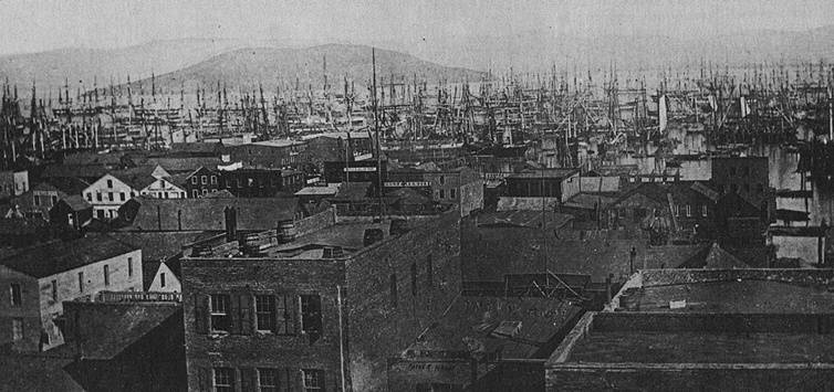
So then a third issue arises. When ships do show up to this growing port, they're abandoned as not only passengers but the entire crew simply takes off to the hills in search of getting rich. (By the way, this included at least one ship of the US Navy.) This picture from 1851 should give you an idea of the mess that was left behind; something like 500 ships were left empty and sitting at anchorage.
So this all coincides to create two results. First, the first wave of piers and buildings in this zone in the early 1850s are on piles rather than land since among other issues there's no material readily available to construct a more solid foundation; construction is mostly done by private industry to turn a profit. But second, the abandoned ships themselves play a significant role. Initially, they serve as improvised warehouses along the wharves, which was a weird but effective reclamation of them given it saved the problems of construction over water and mud. Later, along with trash and sand, they're used to fill in and 'reclaim' the water lots over the next decade or so. They are periodically rediscovered when when modern buildings are constructed over them.
Finally, that geological map of San Francisco? It exists because there's one other issue with the green area: it has historically been a very bad place to be situated during an earthquake, since landfill tends to liquefy and amplify the shockwaves (which is what happened in 1989 with the famous collapses and fires in the Marina; all that was landfill). San Francisco has a map here designating seismic risk zones, and the opening map is taken from the California Geological Survey, which has a Hazards Zone application that lets you explore the entire state for areas that are landfill.
Sources: Americans and the California Dream: 1850-1915 (Starr,
1973), Gold Rush Port: The Maritime Archaeology of San Francisco's Waterfront (Delgado, 2009)
This National Park Service map shows the original coastline of downtown San Francisco as well as several still extant buried ships.
https://www.nps.gov/safr/learn/historyculture/buried-ships-in-san-francisco.htm
Here's another map
The Bay in the SE part of this map is called Mission Bay, here's two more pictures of Mission Bay before it got filled in:
As ships arrived during the Gold Rush beginning in 1849, crew would abandon ship to go prospecting, leaving the ships stuck at port. Captains with nothing better to do turned their ships into places of business and lodging, and built piers out to them which then got connected, covered over, built on, and filled in. Here's some pictures of these abandoned ships from 1849:
https://sf.curbed.com/2017/8/11/16134968/old-photos-sf
In this picture from 1875, you see buildings built atop piers
https://webbie1.sfpl.org/multimedia/sfphotos/AAC-2276.jpg
This picture from 1867 shows the Broadway Wharf, which was more developed than the picture above, it looks like flat road with full buildings built atop it, but this was all water just 30 years before this picture was taken.